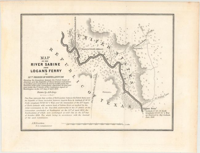
Rare and Important Map That Helped Establish Independent Texas' Eastern Border
"Map of the River Sabine from Logan's Ferry to 32nd Degree of North Latitude...", U.S. Government
Subject: Texas-Louisiana Border
Period: 1842 (published)
Publication: Sen. Doc. 199, 27th Congress, 2nd Sess.
Color: Black & White
Size:
8.4 x 6.5 inches
21.3 x 16.5 cm
This is one of six maps issued with the report on the boundary survey between the Republic of Texas and the United States. The act admitting Louisiana to statehood in 1812 contained a clause defining its original boundaries. When Texas declared its independence in 1835, these borders came into question. This survey was made shortly thereafter. This report of the Joint United States-Texas Boundary Commission depicted the eastern border of Texas for the first time. The map depicts the boundary starting from a point on the river about 1/2 mile above Garrison Creek and down the river to Logan's Ferry (where the boundary ceases to follow the river). The map is minutely detailed and filled with fascinating notations. Drawn by A.B. Gray, engraved by W.J. Stone, and signed by J.H. Overton, U.S. Commissioner. A rare and important part of Texas' cartographic history.
References: Claussen & Friis #413; Day #952A; Martin & Martin p. 36.
Condition: A
Issued folding with minor toning that is mostly confined to the blank margins.