Catalog Archive
Auction 166, Lot 324

"Nova Isthmi Americani, qui et Panamiensis Item Dariensis, Tabula, in qua Urbes Porto Bello, Panama et Carthagena...", Ottens, Reiner and Joshua

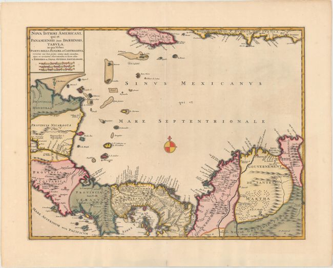
Subject: Central America & Colombia

Period: 1730 (circa)

Publication: Atlas Minor Sive Geographia Compendios…

Color: Hand Color

Size:
21 x 16.1 inches
53.3 x 40.9 cm
Download High Resolution Image
(or just click on image to launch the Zoom viewer)

This is an early edition of this important map of Panama extending from Honduras to Colombia and as far as Jamaica. The map details the major ports along the route of the Spanish treasure ships to and from Cartagena and Portobello, both shown as fortified cities. The history of this map is complicated; it was issued separately and as part of a large six-part map illustrating the War of Jenkin's Ear in 1740-41. This is the separately issued state as it contains its own title cartouche. Further, this map is without the course of the treasure fleet, indicating this is an earlier edition. The earliest known advertisements to sell this map date from May, 1740. However the partnership of Josua and Reiner began in 1725; thus we have dated it circa 1730.

References: Kapp (MCC-73) #36.

Condition: B+

Wide margins and stunning old color with some oxidation of green pigment that has been professionally backed on verso with a few tiny holes in blank areas of map image. Paper is still very stable. A light crease in top-right corner.

Estimate: $550 - $650

Unsold

Closed on 2/14/2018

Archived