Catalog Archive
Auction 166, Lot 289

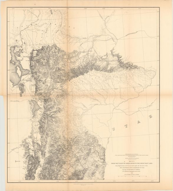
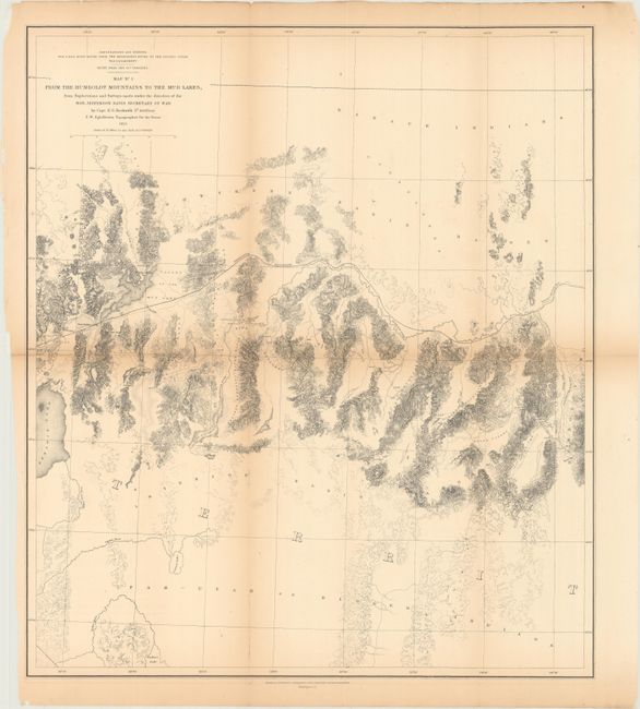
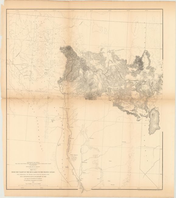
"[Lot of 3] Map. No. 1. From the Valley of Green River to the Great Salt Lake... [and] Map No. 3 From the Humboldt Mountains to the Mud Lakes... [and] Map. No. 4 From the Valley of the Mud Lakes to the Pacific Ocean...", Beckwith, E. G., Capt.

Subject: Utah

Period: 1855 (dated)

Publication: U.S. Pacific Railroad Surveys

Color: Black & White

Size:
17.9 x 20.6 inches
45.5 x 52.3 cm
Download High Resolution Image
(or just click on image to launch the Zoom viewer)

During the 1850s, the U.S. government sponsored an extensive series of expeditions designed to gather information on the vast new territories that had been acquired in western North America. The discovery of gold in California further stimulated westward traffic and heightened the need for a faster and more convenient way to bring the far-flung parts of the country together. In 1853 Congress commissioned the Army's Topographic Bureau to conduct a series of surveys to find a suitable route for a transcontinental railroad. There were six major expeditions; five of them covered the area between the Great Plains and west coast, and the sixth explored the coastal states of California and Oregon. All of these expeditions were accompanied by naturalists and artists to document the landscape, flora and fauna along the route. The reports, maps and lithographs were published in the 13 volume report "Explorations and Surveys to ascertain the most practicable and economical route for a Railroad from the Mississippi river to the Pacific Ocean."

A. Map. No. 1. From the Valley of Green River to the Great Salt Lake; from Explorations and Surveys Made Under the Direction of the Hon. Jefferson Davis, Secretary of War. Extremely detailed map has very fine hachure to indicate mountainous elevations. The map extends from Brown's Hole east of today's Vernal to the Great Salt Lake and south to below Fillmore. The Emigrant Road heads south to California. Several "Proposed Railroad" lines are shown. One crosses the Green River near Black's Fork, continues past Fort Bridger (Wyoming) and on to the Weber River to Ogden City where it turns south. Another leaves the Wasatch Mountains via Timpanogas Canyon and a third heads west from the Oquirrh Mountains.

B. Map No. 3 From the Humboldt Mountains to the Mud Lakes.... This map is filled with topographical detail presented in fine hachure. It extends to include most of the Pyramid Lake, which is passed to the north by the proposed railroad route. An area to the northeast is noted as Unexplored.

C. Map. No. 4 From the Valley of the Mud Lakes to the Pacific Ocean.... This map covers from Pyramid Lake to the Sacramento River in good detail, while the western portions are in skeletal form. The proposed railroad route is delineated plus the one to the south surveyed in 1854. Locates Mount Shasta, Red Bluffs, Marysville, Auburn and the Head of Navigation on the Sacramento River. In the Gold Region the map locates Nevada, Coloma, Placerville and Auburn.

Wheat considers these maps to be excellent "due in large part to Egloffstein's work as Topographer for the Route."

References: Wheat (TMW) #822, #824 & #825.

Condition: B

Issued folding and now flattened and backed with tissue to reinforce and repair a few minor fold separations mainly at the junctions. Toning along the folds.

Estimate: $250 - $325

Sold for: $150

Closed on 2/14/2018

Archived