Catalog Archive
Auction 166, Lot 170

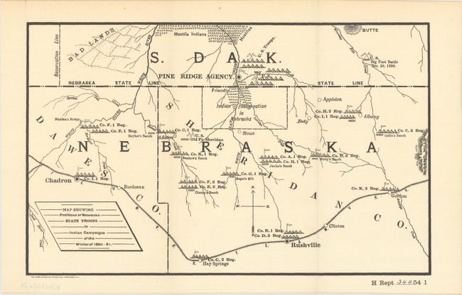
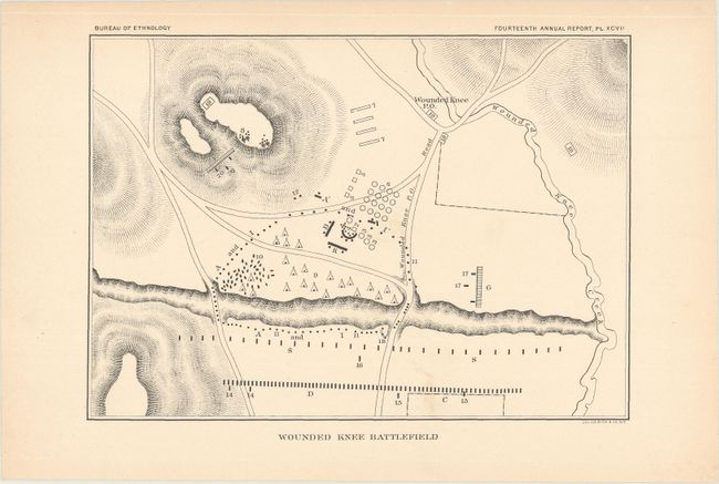
"[Lot of 2] Map Showing Positions of Nebraska State Troops in Indian Campaigns of the Winter of 1890-91 [and] Wounded Knee Battlefield", U.S. Government

Subject: Nebraska & South Dakota

Period: 1896 (circa)

Publication:

Color: Black & White

Size:
See Description
Download High Resolution Image
(or just click on image to launch the Zoom viewer)

A. Map Showing Positions of Nebraska State Troops in Indian Campaigns of the Winter of 1890-91, from HR Doc #344, 54th Congress, 1st Session (12.1 x 7.6"). This fascinating map has considerable historical significance in that it shows the location of the Battle of Wounded Knee, here labeled as Big Foot Battle, Dec 29, 1890. A misunderstanding between soldiers and Indians waiting to surrender at Wounded Knee, South Dakota, touched off the tragic massacre of some 300 Sioux men, women and children. The campaign was an attempt to suppress the Ghost Dance movement. At the height of the tension, Sitting Bull was killed. The map covers a portion of South Dakota and Nebraska and includes Madden's Bridge, the Stryker, Chaney, Swallow, Jarcho, Morey and Collin Ranches, and the towns of Pine Ridge, Gordon, Rushville, and Chadron. Military positions are shown throughout, with notes of friendly and hostile Indian locations. Condition: A crisp impression on a clean sheet. Issued folding. (A+)

B. Wounded Knee Battlefield, from Bureau of Ethnology - Fourteenth Annual Report (8.2 x 5.8"). A close up view of Wounded Knee with camps and positions noted. Depicts Wounded Knee Post Office and Wounded Knee Creek. Condition: Light toning along the sheet edges, otherwise fine. (A)

References:

Condition:

See description above.

Estimate: $170 - $200

Sold for: $120

Closed on 2/14/2018

Archived