Catalog Archive
Auction 165, Lot 92

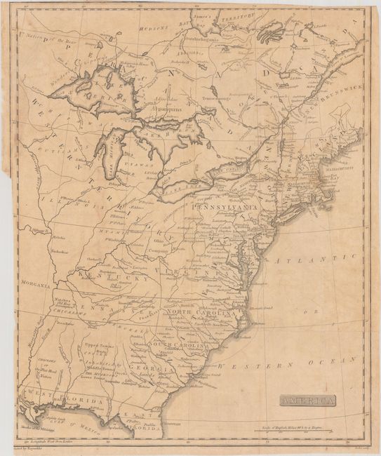
Unique Map Depicting Both Franklinia and Morgania

"America",

Subject: Eastern United States & Canada, Franklinia

Period: 1805 (published)

Publication: The History of the Discovery and Settlement, to the Present Time...

Color: Black & White

Size:
12.9 x 15.9 inches
32.8 x 40.4 cm
Download High Resolution Image
(or just click on image to launch the Zoom viewer)

This fascinating map of the Eastern United States and Canada features the short-lived states of Franklinia in eastern Tennessee (here labeled Tennassee) as well as Morgania in present-day Missouri. The latter was named after George Morgan, a land speculator, who attempted to create a new colony in the then Spanish controlled Louisiana Territory near New Madrid (Morgan gave up this endeavor a few years later). The Ohio Company land grant still appears north of the Ohio River, and Florida is divided between East and West. West of the Appalachians, detail is mostly limited to forts and the locations of numerous Indian tribes. Engraved by John Scoles.

Also included in the lot is the title page from William Mavor's The History of the Discovery and Settlement, to the Present Time, of North & South America, and of The West-Indies. Published by Samuel Stansbury & Co.

References: Dotson & Baker (OWA) #20.

Condition: B

Issued folding with light toning and offsetting. There is a binding trim at left with loss of border.

Estimate: $500 - $650

Sold for: $850

Closed on 11/15/2017

Archived