Catalog Archive
Auction 165, Lot 716

"Wahrhafft Abcontrafehtung der Mechtigen und Vesten Statt Alkair", Munster, Sebastian

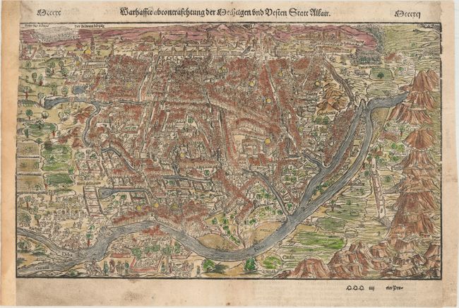
Subject: Cairo, Egypt

Period: 1578 (circa)

Publication: Cosmographey oder Beschreibung Aller Lander...

Color: Hand Color

Size:
15.4 x 9.3 inches
39.1 x 23.6 cm
Download High Resolution Image
(or just click on image to launch the Zoom viewer)

Sebastian Munster (1489 - 1552) was one of the three most renowned cartographers of the sixteenth century, along with Mercator and Ortelius. Munster's Geographia and Cosmographia Universalis were two of the most widely read and influential books of the period. His editions of Ptolemy's Geographia, published between 1540 and 1552, were illustrated with 48 woodcut maps, the standard 27 Ptolemaic maps supplemented by 21 new maps. These new maps included a separate map of each of the known continents and marked the development of regional cartography in Central Europe. The antique geography was a prelude to Munster's major work, the Cosmographia, which was published in nearly 30 editions in six languages between 1544 and 1578 and then was revised and reissued by Sebastian Petri from 1588 to 1628. The Cosmographia was a geographical as well as historical and ethnographic description of the world. It contained the maps from the Geographia plus additional regional maps and city views with nearly 500 illustrations which made it one of the most popular pictorial encyclopedias of the sixteen century.

This early, 16th century woodblock city plan of Cairo has amazing detail of the buildings, gardens, temples, palaces, farms and markets. The Nile is shown with fishing boats, irrigation systems and even crocodiles. The pyramids are also depicted. German text and title Die Statt Alkair on verso.

References: Shirley (BL Atlases) T.MUN-1k #200.

Condition: B+

Light soiling, and remargined at both sides with period-correct paper, with small loss of image and neatline at left.

Estimate: $160 - $190

Sold for: $120

Closed on 11/15/2017

Archived