Catalog Archive
Auction 165, Lot 307

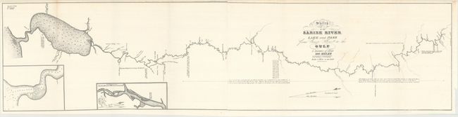
"[Lot of 2] Sketch of the Sabine River Lake and Pass from Camp, Sabine to the Gulf - A Distance of About 300 Miles [With Report]", Eaton, J. H.

Subject: Sabine River, Eastern Texas

Period: 1838 (published)

Publication: HR Doc. #365, 25th Cong., 2nd Session

Color: Black & White

Size:
34.8 x 8.4 inches
88.4 x 21.3 cm
Download High Resolution Image
(or just click on image to launch the Zoom viewer)

This survey was made shortly after Texas declared its Independence in 1835 and appears to have been the basis for a more detailed survey accomplished in 1840 to determine the eastern boundary of Texas. A most desirable and uncommonly seen map. Complete with the original 3 pp accompanying report from Major W.G. Belknap to the Secretary of the War. The report describes the work performed by Lieut. J.H. Eaton to create the map. It also contains the costs incurred to make the waterway navigable and, finally, a short letter from Isaac Wright, Captain of the steamer Velocipede who successfully traveled upstream 300 miles to Sabine "without the least injury to my boat." On two sheets, joined as issued.

References: Claussen & Friis #243; Koepp #I-34-1-4.

Condition: A

Condition code is for the folding map, which is clean and bright with a few minor extraneous creases. Disbound text is very good with light scattered foxing.

Estimate: $275 - $350

Sold for: $160

Closed on 11/15/2017

Archived