Catalog Archive
Auction 165, Lot 185

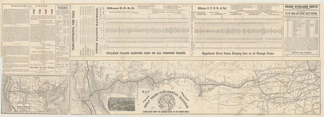
"Map of the Union Central Great Trans-Continental Railroad and Its Connections from the Missouri River to the Pacific Coast", Crofutt, George A.

Subject: Western United States

Period: 1872 (dated)

Publication:

Color: Black & White

Size:
27.4 x 6 inches
69.6 x 15.2 cm
Download High Resolution Image
(or just click on image to launch the Zoom viewer)

This brochure contains a folding map depicting the Union Pacific and Central Pacific Railroad from Omaha to Sacramento and the San Francisco Bay. A second, smaller map (7.7 x 4.3") shows the entire United States along with connecting rail lines. Above the two maps are timetables for both railroads and an editorial note. The verso contains three illustrations and numerous transportation-related advertisements. The full sheet with advertisements measures approximately 35 x 12". This map was originally included in one of Crofutt’s tourist guides.

References:

Condition: B+

The brochure is overall bright and mostly clean with archival tape reinforcement at fold intersections. The brochure is trimmed to the left border of the small map, and there is a 3" edge tear at left confined to the descriptive text that has been closed on verso with archival tape.

Estimate: $180 - $220

Sold for: $200

Closed on 11/15/2017

Archived