Catalog Archive
Auction 165, Lot 170

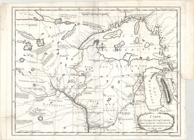
"Carte des Voyages du Cape. Carver, dans la Partie Interieure de l'Amerique Septentrionale, en 1766 et 1767", Carver, Jonathan (Capt.)

Subject: Upper Midwestern United States

Period: 1784 (published)

Publication: Travels Through the Interior Parts Of North America…

Color: Black & White

Size:
13.5 x 10.4 inches
34.3 x 26.4 cm
Download High Resolution Image
(or just click on image to launch the Zoom viewer)

A terrific early map of the region of today's Wisconsin and Minnesota published in a French edition of Travels Through the Interior Parts Of North America…. The map depicts the route of Carver's travels along the Mississippi, Fox, Minnesota and St. Pierre rivers. The map extends from Michigan, here labeled as lands of the Chippewa and Ottawa Indians, to above Lake Superior and west to beyond the Minnesota River. After the French and Indian War the peace settlement gave the British eastern Minnesota, opening the vast territory to their fur traders. Carver spent the winter of 1766-67 with the Sioux on the Minnesota River. He then joined Capt. James Tute's expedition as the mapmaker. Tute's plan was to cross the continent in quest of the Northwest Passage. The plan was not successful but their explorations led Carver to later publish an account of his travels. Carver is credited with traveling farther into the unknown West than any other English explorer before the Revolution. A very early and seldom seen map.

References: Wheat (TMW) #175; Howes #C215.

Condition: B+

A dark impression with faint offsetting and a 0.75" binding tear at right that has been closed on verso with archival material. An edge tear at lower left that just passes the neatline has also been archivally repaired on verso.

Estimate: $800 - $950

Unsold

Closed on 11/15/2017

Archived