Catalog Archive
Auction 165, Lot 127

"A New Map of the United States. Upon Which Are Delineated Its Vast Works of Internal Communication, with the Proposed Routes Across the Continents &c...", Williams, Wellington

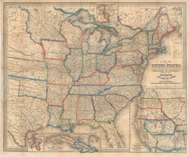
Subject: Eastern United States

Period: 1857 (dated)

Publication:

Color: Hand Color

Size:
29.4 x 24.3 inches
74.7 x 61.7 cm
Download High Resolution Image
(or just click on image to launch the Zoom viewer)

This is the third edition of this highly detailed, vividly colored map according to Wheat (earlier editions were published in 1852 and 1854). It features inset maps of Niagara River and Falls, Havana, the Island of Cuba, and a great Map of California, Oregon, New Mexico Utah &c.. The main map shows the country as far west as the Texas panhandle and the Great Plains, which consists of Minnesota, Nebraska, Kansas, and Indian Territory. There are numerous forts, railroads, trade routes and the tracks of several explorers. The inset map of the West (9.3 x 10.5") shows explorers' routes and immigrant trails, most notably the Oregon Route. The Great Basin in Utah Territory is bounded by the erroneous mountain range labeled Dividing Range between the Waters of the Pacific and the Waters of the Great Basin. In the Northwest, Ft. Nisqually and Olympia are named, and Portland is Oregon City. Fillmore City is the capital of Utah. Copyright dated 1855.

References: Wheat (TMW) #927; cf. Phillips (Maps) p. 901.

Condition: B+

Issued folding and now flattened and backed with tissue to reinforce and repair several tiny fold separations, with minute loss of image at a few fold separations. Additional repairs have been made to a few small chips and edge tears in left border where the map had been previously attached to boards.

Estimate: $400 - $500

Sold for: $300

Closed on 11/15/2017

Archived