Catalog Archive
Auction 164, Lot 5

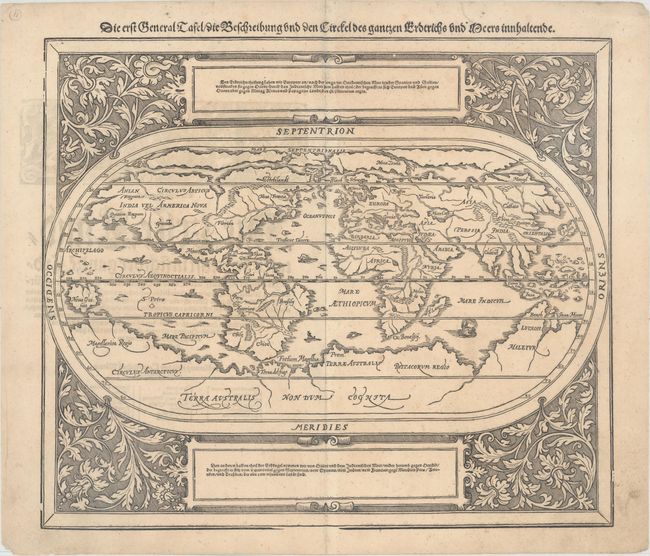
"Die erst General Tafel / die Beschreibung und dun Circkel des Gantzen Erdtrichs und Meers Innhaltende", Munster/Petri

Subject: World

Period: 1588 (circa)

Publication: Cosmographey...

Color: Black & White

Size:
14.2 x 12.3 inches
36.1 x 31.2 cm
Download High Resolution Image
(or just click on image to launch the Zoom viewer)

Sebastian Munster (1489 - 1552) was one of the three most renowned cartographers of the sixteenth century, along with Mercator and Ortelius. Munster's Geographia and Cosmographia Universalis were two of the most widely read and influential books of the period. His editions of Ptolemy's Geographia, published between 1540 and 1552, were illustrated with 48 woodcut maps, the standard 27 Ptolemaic maps supplemented by 21 new maps. These new maps included a separate map of each of the known continents and marked the development of regional cartography in Central Europe. The antique geography was a prelude to Munster's major work, the Cosmographia, which was published in nearly 30 editions in six languages between 1544 and 1578 and then was revised and reissued by Sebastian Petri from 1588 to 1628. The Cosmographia was a geographical as well as historical and ethnographic description of the world. It contained the maps from the Geographia plus additional regional maps and city views with nearly 500 illustrations which made it one of the most popular pictorial encyclopedias of the sixteen century.

This oval woodcut world map appeared in the later editions of Munster's Cosmographia that were published by Sebastian Petri, the son of Munster's step-son, Henricus Petri. The map of the "modern" world is based on Ortelius' map of 1570. It is surrounded by a floral and vine leaf pattern and two strapwork cartouches containing German text. The gothic German title is in the upper margin. Interesting cartographic features of the map include a huge southern continent and a Northern Passage (both Northwest and Northeast) to Asia. The map includes several tiny ships and sea monsters. German text and illustration on verso.

References: Shirley #163; Shirley (BL Atlases) T.MUN-1-l #1.

Condition: A

An excellent impression on a clean, bright sheet. There are two small holes along the centerfold and confined to the blank margins. Remnants of hinge tape on verso. This map usually has condition issues, so this is the nicest example we've listed in over 15 years!

Estimate: $1,400 - $1,700

Sold for: $1,300

Closed on 9/13/2017

Archived