Catalog Archive
Auction 164, Lot 56

"A New and Accurate Map of America. Drawn from the Most Approved Modern Maps and Charts, and Adjusted by Astronomical Observations: Exhibiting the Course of the Trade Winds Both in Atlantic & Pacific Oceans", Bowen, Emanuel

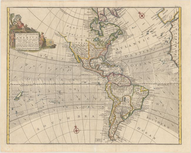
Subject: Western Hemisphere - America

Period: 1744 (circa)

Publication: John Harris' Navigantium atque Itinerantium Bibliotheca

Color: Hand Color

Size:
17.7 x 13.9 inches
45 x 35.3 cm
Download High Resolution Image
(or just click on image to launch the Zoom viewer)

This attractive map of the Americas illustrates the Course of the Trade Winds in Both the Atlantic and Pacific Oceans. In North America, the Pacific Northwest is left open, completely blank and labeled Parts Undiscovered. The coastline stops in the vicinity of Alaska with the notation The Supposed Straits of Annian. The British colonies are shown east of the Appalachian Mountains, with French Louisiana sandwiched between them and the Spanish possession of New Mexico. The only settlements named in the West are Cenis in Texas, Santa Fe and Alamillo in New Mexico, and Casa Grande in Arizona. A very large Lake Superior is shown to contain several islands. In South America, the Amazon River is well delineated but the mythical Xarayes L. still appears as the headwaters for the Rio de la Plata. The map extends from the Salomon Islands in the Pacific to the coastlines of Spain and Africa. The decorative cartouche features Native Americans and wildlife with a treasure chest and a group of European merchants in the background.

References: Shirley (BL Atlases) G.HARR-1a #15.

Condition: B+

Issued folding on paper with fleur-de-lis and "IV" watermarks. There are some extraneous creases that have been pressed flat, one tiny hole along Lake Huron, and an archivally repaired fold separation confined to the bottom blank margin.

Estimate: $375 - $450

Sold for: $190

Closed on 9/13/2017

Archived