Catalog Archive
Auction 164, Lot 398

"St. Christophers, or St. Kitts, Surveyed by Anthony Ravell Esqr. Surveyor General of the Islands of St. Christophers, Nevis, & Montserrat", Jefferys/Sayer

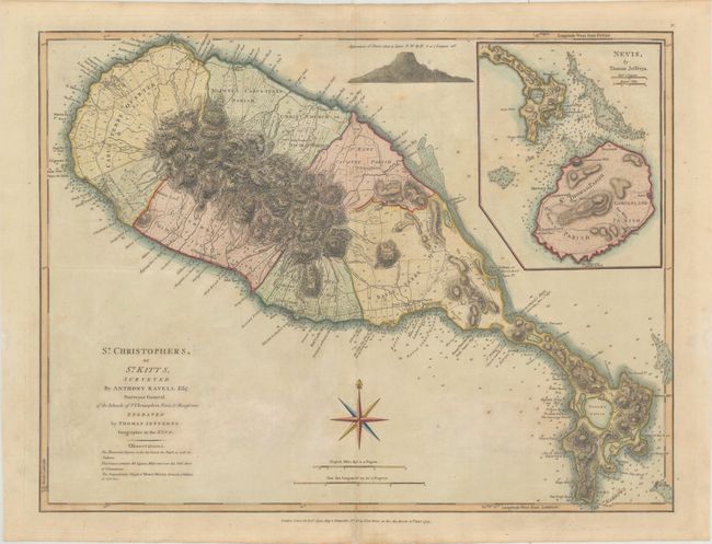
Subject: St. Kitts & Nevis

Period: 1775 (dated)

Publication:

Color: Hand Color

Size:
24.3 x 18.4 inches
61.7 x 46.7 cm
Download High Resolution Image
(or just click on image to launch the Zoom viewer)

Thomas Jefferys was one of the most important English map publishers of the 18th century. His work included prints and maps of locations around the world, but his most notable maps are of North America and the West Indies. He began his career in the map trade in the early 1730s, working as an engraver for a variety of London publishers, and eventually setting up his own shop. In 1746, he was appointed Geographer to the Prince of Wales, and in 1760 he became Geographer to the King. These titles granted access to manuscripts and cartographic information held by the government. In the early 1760s he embarked on an ambitious project to produce a series of English county maps based on new surveys, but ran out of money and filed for bankruptcy in 1766. He then partnered with London publisher Robert Sayer, who reissued many of Jefferys plates and continued to issue new editions after Jefferys' death in 1771. Jefferys' American Atlas and the accompanying West-India Atlas, published post posthumously, are considered his most important cartographic works.

This handsome large-scale map of St. Kitts has numbered surveyed areas and many place names, including some rather salty ones along the coast. The map locates the anchorages, and a note near Limekiln Bay records that the Childs Play Man of War was lost on these Rocks Sept. 2. 1707. The map is simply composed, decorated only with a large fleur-de-lys. This is the second state, with the addition of an inset of Nevis and scale borders. This influential map became the standard 18th century map of the island.

References: Tooley (MCC-81) St. Christopher #42; Sellers & Van Ee #1989.

Condition: B+

Light toning with an archivally repaired centerfold separation that enters less than 1" into map at bottom and two large, faint damp stains in the bottom portion of the image.

Estimate: $400 - $500

Sold for: $300

Closed on 9/13/2017

Archived