Catalog Archive
Auction 164, Lot 216

"A Diagram of a Portion of Oregon Territory", U.S. Government

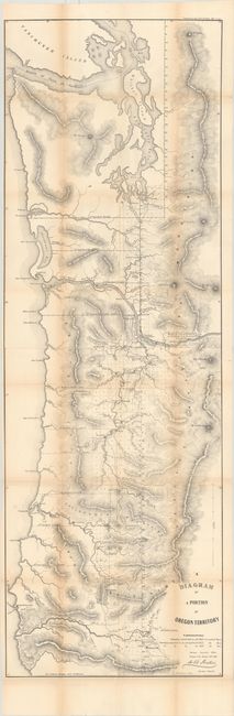
Subject: Northwestern United States

Period: 1852 (dated)

Publication: Senate Ex. Doc. No. 1 2d Sess, 32d Cong.

Color: Black & White

Size:
15.9 x 47.6 inches
40.4 x 120.9 cm
Download High Resolution Image
(or just click on image to launch the Zoom viewer)

This is the rare updated edition of the General Land Office's 1851 map of the coastal area of Oregon Territory. The map spans from the California boundary north to Vancouver Island. It features good detail of rivers and tributaries and locates Portland, Oregon City, Astoria, Salem, Fort Vancouver, Santiam City, Winchester, Olympia, Pacific City, Umpqua, and several others. Mount Rainier, Mount St. Helens, Mount Hood, and various mountain ranges are identified. There is a lot of additional information in this revised edition, including intricate topographical detail, towns surveyed in 1852, and townships proposed to be surveyed in 1853 and 1854. The map is also expanded beyond the 1851 edition, extending to cover land north of Olympia. Lithography by A. Hoen & Co.

References:

Condition: B+

Issued folding with light toning along the folds and some short fold separations. Trimmed close to neatline at left.

Estimate: $240 - $300

Sold for: $800

Closed on 9/13/2017

Archived