Catalog Archive
Auction 164, Lot 180

German Edition of Catesby's Scarce and Important Map of the Southeastern United States

"Carolinae Floridae nec non Insularum Bahamensium cum Partibus Adjacendibus Delineatio ad Exemplar Londinense in Lucem Edita", Seligmann, Johann Michael

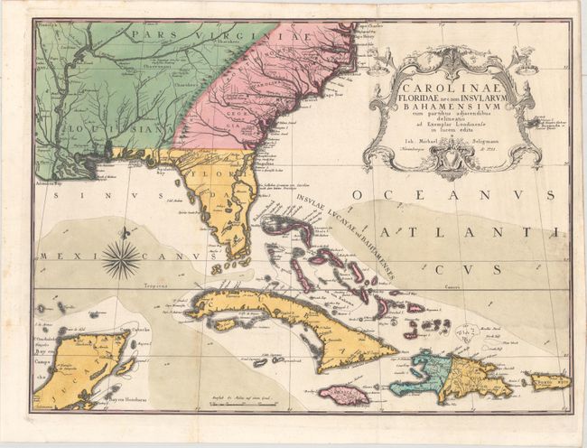
Subject: Colonial Southeast United States, Bahamas & Greater Antilles

Period: 1755 (dated)

Publication: Die Beschreibung von Carolina...

Color: Hand Color

Size:
23 x 16.8 inches
58.4 x 42.7 cm
Download High Resolution Image
(or just click on image to launch the Zoom viewer)

This handsome map extends to include the Bahamas, Cuba, Jamaica, Hispaniola, Puerto Rico and the Yucatan. The map is from the German edition of Mark Catesby's Natural History of Carolina, a seminal work on American flora and fauna. The map depicts the southeastern United States as far west as the Mississippi River and is colored to show the British Colonies in pink, French possessions in green and the regions controlled by Spain in yellow. Catesby drew on several important maps for the content, including the manuscript of Captain John Barnwell (1722) that incorporates several details not found on earlier printed maps. He also used Popple's great 20-sheet map as seen by the river configuration in Georgia and the dotted trail connecting Fort Argyle to Combahee River.

References: Cumming (SE) #292; cf. Schwartz & Ehrenberg pp. 151-152.

Condition: B+

Issued folding and now flattened on a bright sheet of watermarked paper with minor foxing at lower left. There is a binding trim at lower left that has been replaced with period correct paper and an associated expertly repaired 4" binding tear.

Estimate: $5,000 - $6,500

Unsold

Closed on 9/13/2017

Archived