Catalog Archive
Auction 164, Lot 132

"[Wall Map] Mitchell's National Map of the American Republic or United States of North America", Mitchell, Samuel Augustus

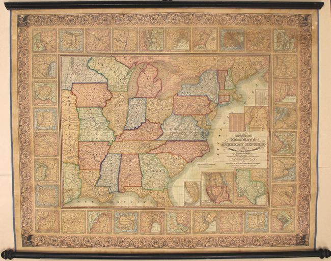
Subject: United States

Period: 1849 (dated)

Publication:

Color: Hand Color

Size:
47 x 38 inches
119.4 x 96.5 cm
Download High Resolution Image
(or just click on image to launch the Zoom viewer)

This beautiful and well engraved wall map was drawn by J.H. Young and engraved by J.H. Brightly. The map extends into Texas, Indian Territory, and Minnesota Territory which contains Dakota. Large insets within the map include northern Maine, southern Florida, Oregon and Upper California, and the State of Texas (shown in its largest extent). The main map is surrounded by 32 inset plans of important cities, along with inset tables containing population statistics for states and territories, as well as various main cities. This large edition should not be confused with the smaller (24 x 34"), and more common, map of the same title.

Editions of this map dated 1843, 44, 45, 46, 48, 49 and 50 are known making this the presumed sixth edition. This version is distinguished from earlier editions by first appearances of Minnesota Territory in the main portion of the map and the gold region in California as shown in the large inset map of Oregon and Upper California.

An impressive and scarce map published at the dawn of rapid westward expansion initiated by acquisition of lands won from Mexico in 1848 and the discovery of gold in California. Post-1846 editions of this map are notably scarcer than earlier editions.

References:

Condition: B+

The map has been professionally conserved with new linen backing, edge ribbon, and ribbon ties on original rollers. The varnish has been removed from the map, and there is some light toning, minor scattered foxing, and a bit of cracking mostly in the blank margins. An attractive example.

Estimate: $1,000 - $1,300

Sold for: $1,400

Closed on 9/13/2017

Archived