Catalog Archive
Auction 163, Lot 348

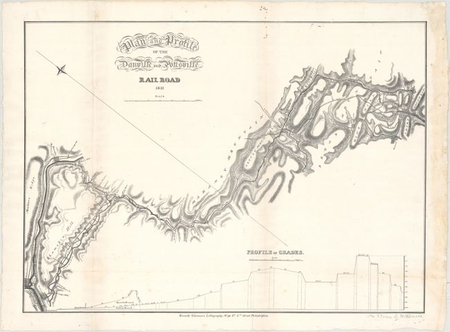
Rare, Early Pennsylvania Railroad Map

"Plan and Profile of the Danville and Pottsville Rail Road",

Subject: Eastern Pennsylvania, Railroads

Period: 1831 (dated)

Publication:

Color: Black & White

Size:
25.1 x 18.2 inches
63.8 x 46.2 cm
Download High Resolution Image
(or just click on image to launch the Zoom viewer)

Chartered in 1826, the Danville and Pottsville Railroad was one of the earliest railroads in Pennsylvania. The line was intended to link the Schuylkill River with the Susquehanna River in order to facilitate the movement of coal to various nearby markets. Construction of the line began concurrently at the end points, but due to the rugged terrain and financial difficulties, the line was never completed (leaving an 18 mile void). Cartographically, the plan shows the proposed railroad winding its way through steep terrain, with roads, canals, drainage, and individual property owners named. The map also depicts the Mount Carbon Railroad and Mill Creek Railroad in the vicinity of Pottsville. Below the map is an elevation profile demonstrating the challenges of the route. Published by Kennedy & Lucas's Lithography in Philadelphia. According to WorldCat, there are only two institutional listings for this map (Library of Congress and Penn State).

References: Modelski #394.

Condition: B+

Issued folding and now flattened with the folds and the right margin reinforced with old paper. There is minor foxing, a few repaired fold separations, and some light damp staining in the right blank margin. Two tiny holes at lower right (in the profile) are only visible when held to light.

Estimate: $950 - $1,200

Sold for: $700

Closed on 6/14/2017

Archived