Catalog Archive
Auction 163, Lot 28

Wells' Map of North America Featuring California as an Island

"A New Map of North America Shewing Its Principal Divisions, Chief Cities, Townes, Rivers, Mountains &c.", Wells, Edward

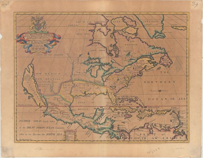
Subject: Colonial North America

Period: 1704 (circa)

Publication: A New Sett of Maps Both of Ancient and Present Geography...

Color: Hand Color

Size:
19.2 x 14.5 inches
48.8 x 36.8 cm
Download High Resolution Image
(or just click on image to launch the Zoom viewer)

This handsome map features the island of California, which is labeled New Albion, discovered by Sir Francis Drake anno 1577. The general outline of the continent follows Father Louis Hennepin's cartography, and the discoveries in the Mississippi Valley are attributed to him. However, the map makes use of fresh sources, especially in the region under English control. Several English settlements are located along the eastern seaboard. A New French Settlement near the mouth of the Mississippi relates to d'Iberville's colony at Biloxi that was founded in 1699. The most notable alteration in the interior is the Ohio River, which is here named the Hotico R. It is shown flowing through the Apalachin M., which inexplicably run east-west in an arc that encloses the Spanish possessions of Florida. The Northwest consists of Parts as yet unknown, the Great Lakes are rather distorted, and a large mythical lake still appears in Carolina. The map is dedicated to His Highness William Duke of Gloucester, with his coat of arms in the title cartouche. It was drawn and engraved by Michael Burghers, the official engraver of the University of Oxford. This is the fourth state of the plate with the additional names St. Johns and Timagaming appearing above Quebec.

References: Burden #758; McLaughlin #142; Tooley (Amer) p. 128, #69, plt. #53.

Condition: C+

Moderate toning and foxing. There are remnants of stiff paper on verso at the sheet corners from a previous framing.

Estimate: $800 - $1,000

Sold for: $650

Closed on 6/14/2017

Archived