Catalog Archive
Auction 162, Lot 8

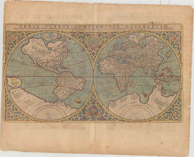
Mercator's Double-Hemisphere World Map

"Orbis Terrae Compendiosa Descriptio quam ex Magna Universali Gerardi Mercatoris...", Mercator, Rumold

Subject: World

Period: 1587 (dated)

Publication:

Color: Hand Color

Size:
20.6 x 11.4 inches
52.3 x 29 cm
Download High Resolution Image
(or just click on image to launch the Zoom viewer)

An elaborate strapwork border surrounds this beautiful double-hemisphere map, and an armillary sphere and 32-point compass rose are tucked between the hemispheres. Rumold Mercator based this map on his father's great world map of 1569. The North Pole is depicted as a landmass surrounding a sea from which four rivers radiate and there is a well depicted Northwest Passage. The huge Terra Australis is shown as a part of Tierra del Fuego, and the lands of Lucach, Maletur and Beach (from the travel account of Marco Polo) are noted along the coast in the vicinity of present day Australia with a large island labeled Iava Minor located in the same region. Japan is shown in a kite-shaped configuration, with the fictitious Satyrorum insule (Satyr's Island) shown above. South America has a bulge on its southwest coast, and New Guinea is depicted in a large, circular configuration. The map embodies many ancient authorities and is a wonderful view of classical cartography. French text on verso, published in 1628. Cracks in the copper plate are visible in the title.


References: Shirley #157; Portinaro & Knirsch XLVIII; Suarez (Veil) #31, plt. XI; Van der Krogt (Vol. I) #01:1A.

Condition: B

Light toning with an extraneous crease at top adjacent to centerfold, a professionally repaired centerfold separation at bottom, and 6 small worm holes in the image that have been professionally infilled. The left margin is narrow, as issued, with a couple of very short tears that have been archivally repaired and a small chip that just enters the neatline.

Estimate: $3,750 - $4,500

Sold for: $2,100

Closed on 4/26/2017

Archived