Catalog Archive
Auction 162, Lot 735

The First Printed Map Devoted to the Pacific

"Maris Pacifici, (quod Vulgo Mar del Zur) cum Regionibus Circumiacentibus, Insulisque in Eodem Passim Sparsis, Novissima Descriptio", Ortelius, Abraham

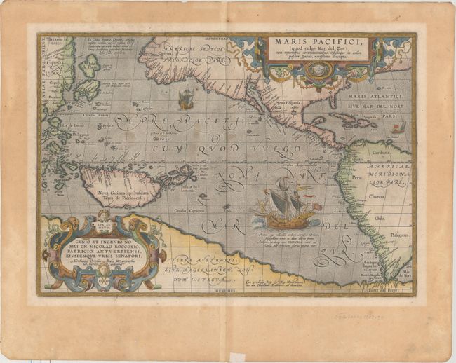
Subject: Pacific Ocean

Period: 1589 (dated)

Publication: Theatrum Orbis Terrarum

Color: Hand Color

Size:
19.5 x 13.6 inches
49.5 x 34.5 cm
Download High Resolution Image
(or just click on image to launch the Zoom viewer)

Ortelius’ seminal map of the Pacific is the first printed map devoted to the Pacific and the first to label the Americas separately as North and South subsequent to Mercator’s 1538 world map. The map draws on the cartography of Frans Hogenberg, Mercator’s world map of 1569, and Portuguese manuscript maps of Bartolomeo de Lasso. It widens the gap between Asia and North America while properly locating the Philippines and Japan, although there is an odd Isla de Plata above Japan. North America is depicted considerably narrower and more correctly at the Tropic of Cancer, and the head of the Gulf of California is shown in a new form with the R. Grande being introduced for the first time, although misplaced. The large southern continent, Terra Australis, stretches over the bottom of the map, but the name Tierra del Fuego appears south of the Strait of Magellan. The map is adorned with two elaborate cartouches and Magellan’s surviving ship Victoria is pictured along with two smaller ships. First state with the date 1589 in the cartouche. Spanish text on verso with printed number 6, published in 1602.

References: Burden #74; Cohen, p. 31-33; Goss (NA) #14; Wheat (TMW) #24; Van den Broecke #12; Suarez, p. 46, 65.

Condition: B+

A crisp impression on paper with a horn watermark, light soiling, and a small abrasion in New Guinea. There is moderate mat burn in the blank margins (about 1/2" from image) and remnants of hinge tape on verso.

Estimate: $8,000 - $9,000

Sold for: $5,300

Closed on 4/26/2017

Archived