Catalog Archive
Auction 162, Lot 263

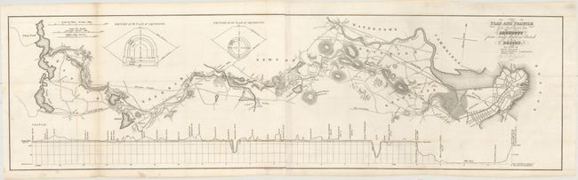
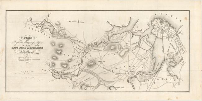
"[Lot of 2] Plan and Profile Survey for an Aqueduct from Long Pond in Natick to Boston [and] Plan of a Proposed Route of Pipes from Spot Pond in Stoneham to Boston",

Subject: Boston, Massachusetts

Period: 1837 (dated)

Publication:

Color: Black & White

Size:
See Description
Download High Resolution Image
(or just click on image to launch the Zoom viewer)

This pair of water supply maps was produced at a time when Boston had doubled its population to 80,000 in just two decades. Growth was accelerating, and Boston could no longer rely on its existing wells, so surveys were performed to find a manageable solution.

A. Plan and Profile Survey for an Aqueduct from Long Pond in Natick to Boston, by L.B. Russell (28.6 x 8.1"). A detailed plan showing rivers, lakes, ponds and topography as well as individual land owners, the Worcester Turnpike, and the B&W Railroad. Includes an elevation profile at bottom and two cross-sections of the planned aqueduct at top. The Lake Cochituate (Long Pond on this map) aqueduct, completed in 1848, was the first major water supply system for the city and served Boston for a century.

B. Plan of a Proposed Route of Pipes from Spot Pond in Stoneham to Boston, by Morse & Tuttle (16.2 x 7.3"). Shows similar features as the map above going to the north of Boston, and identifies "colleges" (Harvard) in Cambridge.

References:

Condition: B+

Dark impressions with a few spots of foxing and occasional faint offsetting.

Estimate: $150 - $180

Sold for: $95

Closed on 4/26/2017

Archived