Catalog Archive
Auction 162, Lot 236

NO RESERVE

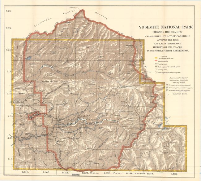
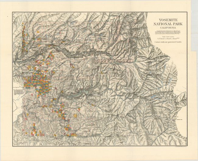
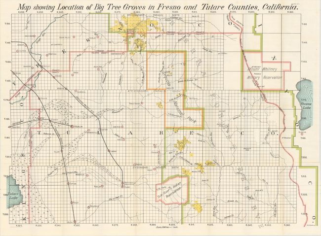
"[Lot of 4] Yosemite National Park Showing Boundaries... [and] Yosemite National Park California [and] Map Showing Location of Big Tree Groves in Fresno and Tulare Counties... [and] Map Showing General Location of Big Tree Groves, California",

Subject: Yosemite National Park, California

Period: 1899-1905 (circa)

Publication:

Color: Printed Color

Size:
See Description
Download High Resolution Image
(or just click on image to launch the Zoom viewer)

This is a great lot of Yosemite and Sequoia National Parks interest. Contains the following maps:

A. Yosemite National Park Showing Boundaries Established by Act of Congress Approved Feb. 7, 1905 and Lands Eliminated Therefrom and Placed in the Sierra Forest Reservation, by U.S. Government, dated 1905 (27.0 x 24.3"). A lovely map of the park with considerable detail and color. The legend provides an explanation of the color codes utilized, showing the limits of the park as established in 1890 by Congress and the newly (Feb. 7, 1905) recommended Park boundary. Described below the map, the Big Tree Grant (Mariposa Grove) is labeled Yosemite Valley Grant within the park. The key also lists existing and suggested trails and roads, the patrol stations and sub-stations, and a permanent military post as recommended by the Yosemite Park Commission the previous year. Highly detailed on a scale of 2 miles to the inch. Condition: Clean and bright. (A)

B. Yosemite National Park California, by U.S. Government, circa 1899 (13.9 x 10.8"). This beautiful stone lithographed map has fine color overprinting to indicate patented lands. It extends to Deadman's Pass in the east; locates White Wolf, Bald Mountain, and various high mountain lakes to the east. Yosemite Valley is at the center with rock formations named. Condition: Clean and bright with a binding trim in the right blank margin. (A)

C. Map Showing General Location of Big Tree Groves, California, by E.H. Stuck, circa 1900 (26.6 x 22.3"). This map extends from the Marysville/Yuba City area south to Bakersfield. The Big Tree groves are highlighted with yellow overprinting. It locates at least sixteen groves including Dinky, Sequoia, Tule River, Fresno, Merced, Tuolumne, Calaveras, Stanislaus, and the North groves. Other entities which contain groves are also shown: Mt. Whitney Military Reserve, Tule River Indian River, etc. Condition: Minor offsetting, some short separations at fold intersections, and an area of light scattered foxing at bottom left. (B+)

D. Map Showing Location of Big Tree Groves in Fresno and Tulare Counties, California, by E.H. Stuck, circa 1900 (36.6 x 26.6"). Centered on Sequoia National Park, the map details the groves throughout the region. It extends to include Selma and part of Tulare Lake in the west and Mount Whitney Military Reservation in the east. There is excellent detail of towns and villages, mining camps, watershed, and more. Condition: Some short separations at fold intersections and minor scattered foxing along a few folds. (A)

References:

Condition:

All the maps are issued folding. See description above for additional details.

Estimate: $150 - $190

Sold for: $150

Closed on 4/26/2017

Archived