Catalog Archive
Auction 162, Lot 224

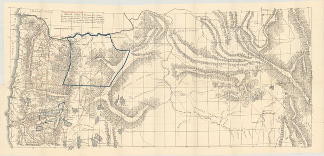
"Sketch Map of Oregon Territory. Exhibiting the Locations of the Various Indian Tribes. The Districts of Country Ceded by Them... [with report]", U.S. Department of Interior

Subject: Northwestern United States

Period: 1893 (published)

Publication: Sen. Ex. Doc. No. 25, 53rd Congress, 1st Session

Color: Printed Color

Size:
35.4 x 16.5 inches
89.9 x 41.9 cm
Download High Resolution Image
(or just click on image to launch the Zoom viewer)

This is the printed version of the 1855 manuscript map of the same title by George Belden that is held in the Library of Congress. It covers the region from the Wind River Mountains to the Pacific Ocean and shows lands held by Indians, lands ceded by Indians and the cessation dates, and good information concerning topography, rivers, trails, forts, and more. Despite the map's publication date of 1893, the information is only current to 1855, and the report states that it is a copy of Belden's map. Included with the map is the original full 58 page disbound report.

References:

Condition: A

The map is clean, bright, and near fine with just a few tiny splits at fold intersections. Disbound report is very good with light toning. Condition code is for the map.

Estimate: $200 - $250

Sold for: $120

Closed on 4/26/2017

Archived