Catalog Archive
Auction 162, Lot 217

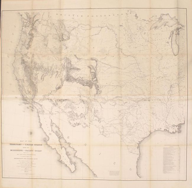
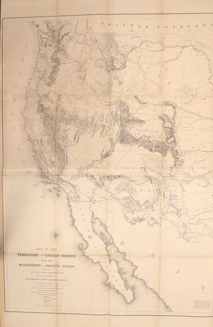
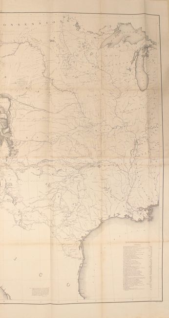
Warren's General Map - One of the Most Important Maps of the American West

"Map of the Territory of the United States from the Mississippi to the Pacific Ocean Ordered by the Hon. Jeff'n Davis, Secretary of War...", Warren, Lieut. G. K.

Subject: Western United States

Period: 1857 (dated)

Publication: U.S. Pacific Railroad Surveys

Color: Black & White

Size:
46.3 x 42.3 inches
117.6 x 107.4 cm
Download High Resolution Image
(or just click on image to launch the Zoom viewer)

Known as "Warren's General Map," this is a monumentally important map that is considered to be the first accurate overall picture of the region. Wheat considered it so important that he dedicated eight pages to its description and called it the most important map produced by the Topographical Engineers. Drawn on the polyconic projection, the map culminated a half-century of government explorations beginning with Lewis & Clark. Only 24 years old when assigned the task, Warren used information from the U.S. Land Office, the Coast Survey, Topographical Engineers, the Adjutant General, the Quartermaster General, the Indian Bureau, and Smithsonian Institution to obtain the latest information in developing this map. The majority of the map was completed by 1854, but it was not fully complete when the first railroad survey report was published in 1855 and thus did not accompany all editions. A remarkable and scarce map that represents the best geological knowledge of the day. Printed on two sheets and joined, as issued.

References: Wheat (TMW) #936.

Condition: B+

Folding, as issued. The top sheet is lightly toned, while the bottom sheet only has toning along the folds. There are some short fold separations and a couple of short tears that have been archivally repaired. A much nicer example than is typically found.

Estimate: $1,200 - $1,500

Sold for: $1,400

Closed on 4/26/2017

Archived