Catalog Archive
Auction 162, Lot 154

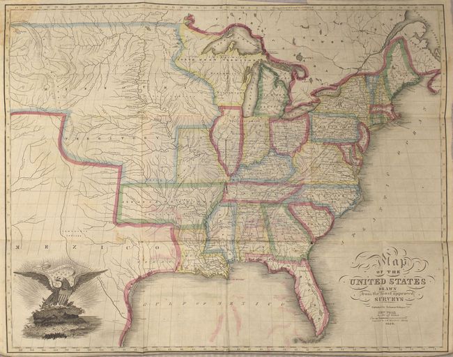
"Map of the United States Drawn from the Most Approved Surveys", Schoyer, Solomon

Subject: Eastern United States

Period: 1826 (dated)

Publication:

Color: Hand Color

Size:
20.8 x 16.3 inches
52.8 x 41.4 cm
Download High Resolution Image
(or just click on image to launch the Zoom viewer)

This scarce folding map was published by Solomon Schoyer and engraved by G.W. Merchant in Albany. According to the David Rumsey Map Collection, this map was a direct copy of Anthony Finley's map that was published in both pocket and atlas forms. Cartographically, the map extends to the Rocky Mountains with the huge Missouri Territory taking in the entire west. The new state of Missouri is also depicted without its "boot." The large Arkansas Territory incorporates present-day Oklahoma, and North West Territory includes both Wisconsin and eastern Minnesota. Texas is named and part of Mexico. Decorated by the United States emblem at lower left. Folds into orange stiff wrappers (4 x 6").

References: Graff #3706; Rumsey #2201.

Condition: B

Issued folding with light color offsetting, a few spots of foxing, and a chip in the top left corner of the map that has been repaired on verso with old paper. There are two fold separations at the center of the map where it was adhered to the covers, as well as a few other small splits at fold intersections.

Estimate: $500 - $650

Sold for: $350

Closed on 4/26/2017

Archived