Catalog Archive
Auction 162, Lot 115

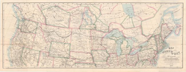
"Map of the Northwest from Explorations by the United States Engineers & Royal Engineers of England and Union & Northern Pacific R.R. Surveys [in] The Seat of Empire", Bien, Julius

Subject: United States & Canada

Period: 1870 (published)

Publication:

Color: Hand Color

Size:
41.1 x 15.1 inches
104.4 x 38.4 cm
Download High Resolution Image
(or just click on image to launch the Zoom viewer)

This uncommon map details the route of the Northern Pacific Railway from Michigan's U.P. to Portland, Seattle and Olympia. The map stretches from New England to the Pacific Northwest, south to include San Francisco and Denver, and north into Canada showing most of British Columbia and all of Alberta, Saskatchewan, Winnipeg, Moose, Bittibee and most of James Bay. The map is remarkably detailed with all rails throughout the area delineated as well as the watersheds, wagon roads and many towns named. Isothermal lines give the mean annual temperature in 10°F increments. With many interesting notations including the location of coal in several places, the winter home of buffaloe, and identifies land types including pasture and timber. One notation in northeastern Montana states the region is "Wide & fertile Valley well timbered." Lithography by the N.Y. Lithographic, Engraving and Printing Co. of Julius Bien. The map is hand colored in outline, a rarity for the Julius Bien company.

The map is housed in the rear pocket of Charles Coffin's The Seat of Empire that details his travels via railroad from Chicago to Portland. 232 pages, 6 plates, and folding map. 12mo, hardbound in green cloth with gilt illustration on front cover.

References:

Condition: B+

The map is very good with a bit of light toning along a few folds and one small split at a fold intersection. Text and plates are near fine with just an occasional spot of foxing. Exterior is near fine with minimal shelf wear.

Estimate: $200 - $250

Sold for: $160

Closed on 4/26/2017

Archived