Catalog Archive
Auction 161, Lot 820

NO RESERVE

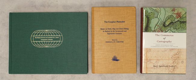
"[Lot of 3] Maps, Globes, Atlases and Geographies Through the Year 1800 - The Eleanor Houston and Lawrence M.C. Smith Cartographic Collection... [and] The Compleat Plattmaker... [and] The Commerce of Cartography...",

Subject: References

Period: 1978-2005 (published)

Publication:

Color:

Size:
See Description
Download High Resolution Image
(or just click on image to launch the Zoom viewer)

A. Maps, Globes, Atlases and Geographies Through the Year 1800 - The Eleanor Houston and Lawrence M.C. Smith Cartographic Collection at the Smith Cartographic Center, University of Southern Maine, by James E. Mooney, published 1988, printed color (11.3 x 8.8"). This catalogue features six hundred entries from the cartographic collection of Eleanor Houston and Lawrence M.C. Smith, donated to the University of Southern Maine. It includes several items described as "improcurable" by Kenneth Nebenzahl in his foreword. The book includes a preface by James E. Mooney and an introduction by Philip Chadwick Foster Smith, the couple's son-in-law. The catalogue is accompanied by 48 illustrations, some in full color. One of 1250 copies. Hardbound in green cloth with gilt title on spine and a gilt decoration and title on the front cover. 145 pp.

B. The Compleat Plattmaker -Essays on Chart, Map, and Globe Making in England in the Seventeenth and Eighteenth Centuries, by Norman J.W. Thrower, published 1978, black & white (6.3 x 9.6"). This reference is a compilation of essays on English map, chart, and globe-making in the 17th and 18th centuries, by notable authors including Wallis, Verner, Woodward, and Thrower. 241pp, with many b&w illustrations and an extensive index. Hardbound with embossed cloth covered boards.

C. The Commerce of Cartography - Making and Marketing Maps in Eighteenth-Century France and England, by Mary Sponberg Pedley, published 2005, printed color (6.4 x 9.4"). This engrossing book is a much-needed study on the commercial cartography boom during the Enlightenment, covering not just the compilation, production, and marketing of maps, but also the public's reception of them. It includes 41 illustrations and 8 color plates. Hardbound in green cloth with gilt title on the spine and an illustrated dust jacket. 345 pp.

References:

Condition: A

All three books are in near fine condition, with just a minor amount of shelf wear.

Estimate: $80 - $110

Sold for: $60

Closed on 2/8/2017

Archived