Catalog Archive
Auction 161, Lot 665

One of the Earliest Obtainable Maps of Arabia

"[Title on Verso] Tabula Sexta Asiae Complectitur Arabam Felicem, & Carmaniam", Ptolemy/Fries
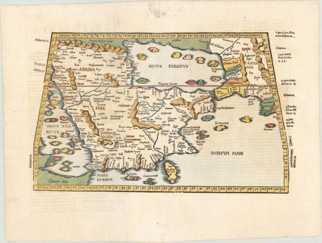
Subject: Arabia

Period: 1541 (published)

Publication: Claudii Ptolemaei Alexandrini Geographicae…

Color: Hand Color

Size:
17.9 x 10.8 inches
45.5 x 27.4 cm
Download High Resolution Image
(or just click on image to launch the Zoom viewer)

Claudius Ptolemy was a mathematician, astronomer and geographer who worked in Alexandria, then a part of the Roman Empire, in the 2nd century AD. One of the most learned and influential men of his time, his theories dominated both astronomy and geography for nearly 1500 years. His writings were kept alive by Arabic scholars during the Middle Ages and reemerged in Europe during the Renaissance. The birth of printing led to wide dissemination of his great works on astronomy and geography. There were a number of editions of his Geographia beginning in 1477. These early editions contained maps based on his original writings, known as Ptolemaic maps. As geographic knowledge increased with the explorations of Columbus, Magellan, Cabot and others, maps of the New World were added, and maps of the Old World were revised. Ptolemy's Geographia continued to be revised and published by some of the most important cartographers including Martin Waldseemuller, Sebastian Munster, Giacomo Gastaldi, Jodocus Hondius, and Gerard Mercator (whose last edition was published in 1730).

This fine woodblock is an early Ptolemaic map of the Arabian Peninsula here called Arabia Felix. It is a fairly good representation of the peninsula, although Ptolemy overestimated the width of the southern part of the peninsula and distorted the shape of the Arabian Gulf. The map is presented on a trapezoidal projection with parallels and meridians (forerunners of lines of longitude and latitude) enumerated in the borders. The title appears on verso along with Latin text. Laurent Fries produced the woodblocks for this edition of Ptolemy's Geography in a reduced version of the Waldseemuller maps from the 1513 edition.

References: Mickwitz & Miekkavaara #211-20; Al Ankary #7.

Condition: A

A clean and bright example on paper with a bunch of grapes watermark and a couple of old manuscript notations. There are a few tiny worm tracks along the centerfold and a printer's crease adjacent to the centerfold.

Estimate: $900 - $1,100

Sold for: $550

Closed on 2/8/2017

Archived