Catalog Archive
Auction 161, Lot 436

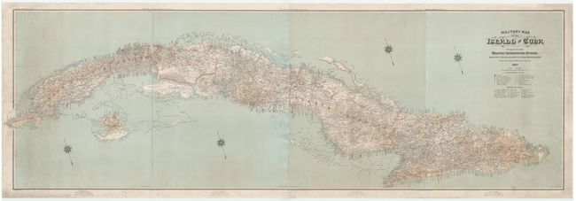
Wall Map of Cuba Prepared for Spanish-American War

"Military Map of the Island of Cuba Prepared in the Military Information Division Adjutant General's Office, War Department from the Latest Official Sources", U.S. War Department

Subject: Cuba

Period: 1897 (dated)

Publication:

Color: Printed Color

Size:
92.5 x 30.3 inches
235 x 77 cm
Download High Resolution Image
(or just click on image to launch the Zoom viewer)

This massive four-sheet map measures 8 feet in length and contains incredible detail of the island of Cuba. The map was created in preparation for the Spanish-American War, a 10 week-long conflict that was primarily fought over Cuban independence. The Americans won the short battle which gave them temporary control of Cuba and possession of Puerto Rico, Guam and the Philippines, thus eliminating Spain's final possessions in the Americas and Asia. The map shows Cuba divided into the 6 provinces established by the Spanish colonial government in 1879. There is excellent detail of towns, telegraph stations, military trenches, railroads, highways, wagon roads, and even foot paths. Below the title is a legend and a list of abbreviations used on the map. Each sheet bears a compass rose pointing north-northwest. The first, second and fourth sheets were drawn by C. H. Ourand, while the third sheet was drawn by W. Morey, Jr. Photolithography by Julius Bien & Co. Printed on 4 separate sheets and joined.

References:

Condition: B+

The majority of the map is in very good condition with light soiling, a few spots of foxing, and some tiny abrasions. The far right and left sides of the map have more moderate soiling, with a number of small abrasions and some minor cracking. Professionally mounted on linen.

Estimate: $2,000 - $2,300

Sold for: $1,500

Closed on 2/8/2017

Archived