Catalog Archive
Auction 161, Lot 320

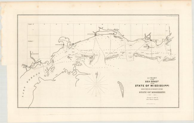
"A Chart of the Sea Coast of the State of Mississippi Executed by Authority of the State of Mississippi", Wheeler, John
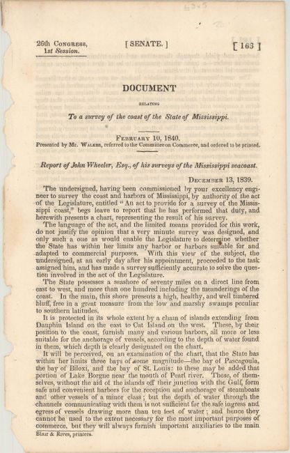
Subject: Mississippi

Period: 1839 (dated)

Publication: Sen. Doc. 163, 26th Cong., 1st Sess.

Color: Black & White

Size:
20.1 x 11.6 inches
51.1 x 29.5 cm
Download High Resolution Image
(or just click on image to launch the Zoom viewer)

This map was prepared by a state-funded survey that detailed the coastline and islands offshore. Covers the region from the lighthouse west of Pearlington to beyond Pascagoula. Includes simple town plans of Pascagoula, Biloxi, Mississippi City (now part of Gulfport), Christanne (now Pass Christian), Shieldsboro (now Bay St. Louis), and Pearlington. Offshore soundings and numerous islands are delineated, including Horn, Ship, Cat and Deer Islands, the Malheureux Isles and N. Chandeleur Island. Surveyed in 1839 by John Wheeler, Engineer. Accompanied by the original report from Wheeler to the Governor of Mississippi, A.G. McNutt, remarking on the benefits for shipping inside the Mississippi barrier islands, and even contemplating the re-opening of Bayou Manchac for a Mississippi River steamboat connection.

References: Claussen & Friis #336.

Condition: A

An early and very strong impression with the layout lines on title still evident. A trace of erasable offsetting, still fine. There are a few spots of foxing confined to the blank margins.

Estimate: $190 - $220

Sold for: $100

Closed on 2/8/2017

Archived