Catalog Archive
Auction 161, Lot 271

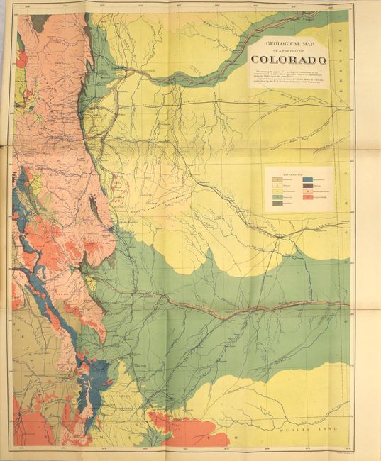
"Geological Map of a Portion of Colorado [in] Artesian Wells upon the Great Plains...", U.S.D.A.

Subject: Colorado

Period: 1882 (published)

Publication:

Color: Printed Color

Size:
19.6 x 25.4 inches
49.8 x 64.5 cm
Download High Resolution Image
(or just click on image to launch the Zoom viewer)

This report was commissioned during a period of western settlement when available surface water supplies in the region were first starting to be recognized as limited and inadequate for agricultural development. Based on limited information and well data available at the time, the authors found the geological conditions of the region to offer little encouragement for the development of groundwater as a significant water supply source, partly due to the great depth of water-bearing formations underlying the Great Plains. The map covers all of eastern Colorado extending from Buena Vista, Leadville, and Frisco on the west to the state line on the east. In geological detail and coloring, it is identical to the eastern portion of Hayden's geological map of Colorado (taken from the Hayden's Colorado Atlas), but bears a different title and lacks the map index lines found on the Hayden map. 37 pages, hardbound in quarter leather with tips over marbled paper boards.

References:

Condition: B

The colorful map has numerous fold separations that have been mostly closed on verso with tape along with some minor tape stains on recto. Text is very good with light toning. Light wear to extremities.

Estimate: $130 - $160

Sold for: $130

Closed on 2/8/2017

Archived