Catalog Archive
Auction 161, Lot 254

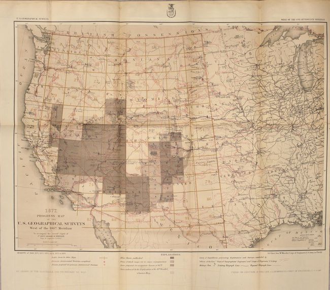
"Progress Map of the U. S. Geographical Surveys West of the 100th Meridian... [in] Annual Report Upon the Geographical Surveys West of the One-Hundredth Meridian in the States and Territories of California, Oregon, Nevada, Texas, Arizona, Colorado...", Wheeler, George (Lt)

Subject: Western United States

Period: 1877 (published)

Publication:

Color: Printed Color

Size:
22.3 x 16.2 inches
56.6 x 41.1 cm
Download High Resolution Image
(or just click on image to launch the Zoom viewer)

The 1870s was a period of intense effort, by such prominent people as Clarence King, Ferdinand Hayden, and John Wesley Powell, to advance the geographical knowledge of the West. These various surveys presented a threat to the Army's supremacy in the field of mapping and to the related appropriations from Congress. As a result of these pressures, the Army Corp of Engineers developed a plan to systematically survey the entire West to be called the U.S. Geographical Surveys West of the One Hundredth Meridian. The region was divided up into 95 rectangles, with atlas sheets to be prepared for each, comprising an area 2°45' of longitude and 1°40' of latitude on a scale of eight miles to the inch. Lieutenant George Wheeler was chosen to head this immense project. Surveys were conducted each summer from 1872 to 1878, after which Congress cut off appropriations for field work; thus the survey was not completed as originally envisioned. Wheeler published annual reports from 1873 to 1884, as well as the final Geographical Report published in 1889. The maps from this report are a valuable document of the record of Western exploration.

A remarkable and attractive map that reflects the survey efforts in the West, including the survey seasons of 1869, and 1871 through 1876. It is a detailed representation of the various routes of western expeditions and the important surveys of King (40th parallel), Wheeler, Powell and Hayden. Among the details are the locations of occupied and abandoned posts, astronomical stations, signal service stations, telegraphic lines, and the routes of cattle droves and trains. The progress maps are among the most interesting, informative and useful maps of the West. The map is still bound into Wheeler's 124 page annual report for 1877 and includes a single-page "Sketch of Portions of Colorado and New Mexico..." and a folding profile view. Octavo, hardbound in brown quarter cloth over boards with gilt title on spine.

References:

Condition: B+

The map has light toning and offsetting with a short binding tear at right that just passes the neatline. Text has light toning. Covers have light wear and staining with a few chips to the spine.

Estimate: $150 - $180

Sold for: $110

Closed on 2/8/2017

Archived