Catalog Archive
Auction 161, Lot 226

"Map of the Southern States, Including Rail Roads, County Towns, State Capitals, County Roads, the Southern Coast from Delaware to Texas...", Harper's Weekly

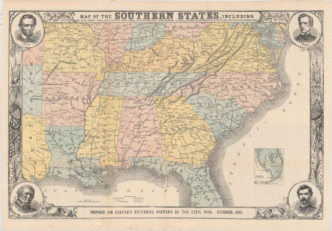
Subject: Southern United States

Period: 1863 (dated)

Publication: Harper's Pictorial History of the Civil War

Color: Hand Color

Size:
30.3 x 20.1 inches
77 x 51.1 cm
Download High Resolution Image
(or just click on image to launch the Zoom viewer)

This terrific Civil War map shows good detail of the towns, villages, railroads, and the ship blockade of the south. The title continues along the bottom: "Prepared for Harper's History of the Rebellion. December, 1863." Surrounded by a very decorative border, it features portraits at each corner of Lincoln, Seward, Gen. Scott, and Gen. McClellan. An inset of "Florida. Southern Part." lies at lower right. On the verso are three black and white wood engraved birds-eye views, two single page and a large double page. The double page view details the region around the Chesapeake Bay and is titled "Pictorial Map of Portions of Delaware, Maryland, Virginia, and North Carolina…" The other two are "Balloon View of Fortress Monroe and Hampton Roads" and "Balloon View of the Seat of War." An uncommon issue.

References: cf. Stephenson (CW) 14.55, 32.9, 37.

Condition: B+

Issued folding with several small fold separations repaired on verso with hinge tape. There are light abrasions along the centerfold with minor loss of image.

Estimate: $150 - $180

Sold for: $140

Closed on 2/8/2017

Archived