Catalog Archive
Auction 161, Lot 137

Rare Map of the British Colonies Just After the French & Indian War

"A New and Accurate Map of the British Dominions in America, According to the Treaty of 1763; Divided into the Several Provinces and Jurisdictions...", Kitchin, Thomas

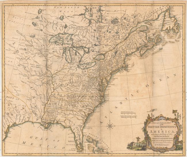
Subject: Colonial Eastern United States & Canada

Period: 1769 (circa)

Publication:

Color: Hand Color

Size:
24.6 x 20.6 inches
62.5 x 52.3 cm
Download High Resolution Image
(or just click on image to launch the Zoom viewer)

This rare historical map illustrates the British colonies after the Treaty of Paris and at the conclusion of the French and Indian War in America. The treaty ended French colonial ambitions in North America with minor exceptions. As a result, Spain ceded East and West Florida to Great Britain, France relinquished the title to the Louisiana Territory to Spain, and the Mississippi River was established as the British-Spanish Boundary. The map reflects the claims of the southern colonies that their charters extended to the Mississippi River, including Virginia, North Carolina, South Carolina, and Georgia. Also of interest are the names and locations of many Indian tribes and nations located away from the more populated areas of English settlements. The map extends west well past the Mississippi River to include portions of Texas, labeled Part of New Mexico and Country of the Cenis. The Mississippi River ends abruptly in the area of present-day Minnesota, with the notation Parts Undiscover'd to the north, and a note further south along the Mississippi states that "thus far the Mississipi has been ascended." Additional notations appear just north of the Missouri River - "Extensive Meadows full of Buffaloes" - and just south of the river - "Country full of Mines." The mythical islands of I. Philippeaux and I. Pontchartrain still appear in Lake Superior. This map appeared in several publications, including The Maps and Charts to the Modern Part of the Universal History and John Knox's Historical Journal of the Campaigns of North America, and was also separately issued.

References: McCorkle #766.1; Sellers & Van Ee #124; Stevens & Tree #7B.

Condition: B

A nice impression, issued folding, on watermarked paper with moderate scattered foxing, light offsetting, and a small paper flaw at left near the "s" of Osages. The bottom margin has been trimmed close to the neatline.

Estimate: $1,400 - $1,700

Sold for: $800

Closed on 2/8/2017

Archived