Catalog Archive
Auction 160, Lot 9

One of the First Ptolemaic Maps to Name America

"Orbis Typus Universalis Iuxta Hydrographorum Traditionem Exactissime Depicta", Fries, Lorenz
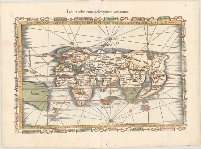
Subject: World

Period: 1541 (published)

Publication: Claudii Ptolemaei Alexandrini Geographicae…

Color: Hand Color

Size:
18.9 x 12.6 inches
48 x 32 cm
Download High Resolution Image
(or just click on image to launch the Zoom viewer)

Claudius Ptolemy was a mathematician, astronomer and geographer who worked in Alexandria, then a part of the Roman Empire, in the 2nd century AD. One of the most learned and influential men of his time, his theories dominated both astronomy and geography for nearly 1500 years. His writings were kept alive by Arabic scholars during the Middle Ages and reemerged in Europe during the Renaissance. The birth of printing led to wide dissemination of his great works on astronomy and geography. There were a number of editions of his Geographia beginning in 1477. These early editions contained maps based on his original writings, known as Ptolemaic maps. As geographic knowledge increased with the explorations of Columbus, Magellan, Cabot and others, maps of the New World were added, and maps of the Old World were revised. Ptolemy's Geographia continued to be revised and published by some of the most important cartographers including Martin Waldseemuller, Sebastian Munster, Giacomo Gastaldi, Jodocus Hondius, and Gerard Mercator (whose last edition was published in 1730).

This highly desirable Ptolemaic world map is an excellent example of the evolving (yet still warped) medieval conception of the world's geography. Fries used Waldseemuller's 1513 edition of Ptolemy's Geographia as the source for most of the maps in his own edition, but this is Fries' own work, and it is even more inaccurate than Waldseemuller's rendering of the modern world. The name America appears for the first time on a Ptolemaic map and is used to identify South America, which appears with an entirely speculative western coastline. Even relatively well-known areas of the Old World become flawed in Fries' depiction. In Europe, Scotland and England are separate islands, and India is split into a double peninsula. Despite these distortions -- or perhaps because of them -- this map is much sought after. The map is bordered by a chain of banners naming the winds. An alternate title appears above the map: "Tabula Orbis cum Descriptione Ventorum." When changes were made to this map for the 1535 edition, the plate developed a horizontal crack running from the middle of the right side of the map, also visible in this example.

References: Shirley #48; Mickwitz & Miekkavaara #211-50.

Condition: A

An excellent impression on paper with a bunch of grapes watermark. There are professional repairs to several clean cuts along the centerfold at top.

Estimate: $7,000 - $8,500

Sold for: $5,500

Closed on 11/16/2016

Archived