Fascinating Map of the Americas with Unusual Features
"A New Map of America from the Latest Observations", Senex, John
Subject: Western Hemisphere - America
Period: 1719 (circa)
Publication: A New General Atlas
Color: Hand Color
Size:
22 x 19 inches
55.9 x 48.3 cm
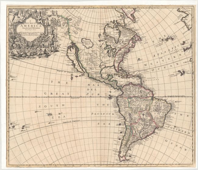
This is a very curious and fascinating map of the Americas. There are several interesting features that don't appear on other maps of the period. Senex's depiction of the northwestern part of North America is most unusual with the coastline continuing far to the north of the island of California. Two lakes (L. Aquinanbock and L. of Isles) appear along the coastline with the place names (Desolation and Zapezipin) and several offshore islands. The western interior is filled with a huge lake labeled The Great Lake of Thoago or Thoya, from which two rivers flow to the Pacific. Another remarkable feature of the map is a wide unnamed river flowing from Carolina into the Gulf of Mexico. South America takes on an unusual shape with the mythical Parime L and enlarged Rio de Plata. The splendid title cartouche is decorated with natives, parrots, turtles, serpents and scenes of battle and cannibalism. The map is dedicated to the Earl of Berkshire, Deputy Earl Marshal of England and engraved by John Harris. Mead Cain attributes the source of the map to Robert Morden, whose map also includes the odd Northwest coastline and fallacious river flowing from Carolina.
References: Cain (TMC-57) p.4; McLaughlin #193; Tooley (Amer) #81, p.130; Wagner #520.
Condition: B+
On watermarked paper with faint scattered foxing. Trimmed close to the neatline on all sides and mounted on archival paper to create margins.