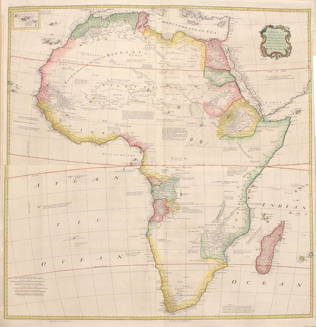
"Africa Performed by the Sr. Danville Under the Patronage of the Duke of Orleans...", Bolton, Solomon
Subject: Africa
Period: 1751 (circa)
Publication: The Universal Dictionary of Trade and Commerce...
Color: Hand Color
Size:
38.4 x 38.9 inches
97.5 x 98.8 cm
This massive wall map of Africa was published in Malacy Postlethwayt's The Universal Dictionary of Trade and Commerce... as four separate sheets which have been joined in this example. Based on the cartography of d'Anville, it features fine detail along the coastline, including place names, political divisions, rivers, and more, but much of the interior remains unexplored. Plenty of notes appear throughout the map, providing information on the land, its native inhabitants, the wildlife, and more. Above the equator, the speculative twin lakes to the north of the Lunar Mountains are shown, with an extended note nearby discussing the mystery of the Nile's source. Surrounding islands are located, such as Madagascar, Cape Verde, and the Canary Islands. A small inset at top left focuses on the Azores. There is a decorative title cartouche at top right that credits Bolton with revisions. Engraved by Emanuel Bowen.
References: Shirley (BL Atlases) G.POST-1a #20-23.
Condition: A
A nice impression with some minor imperfections along the joints and a long printer's crease on the southwest sheet. The margins have been extended in several areas to create uniform margins.