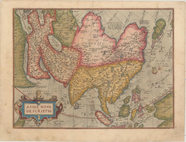
First Plate of Ortelius' Important Map of Asia
"Asiae Nova Descriptio", Ortelius, Abraham
Subject: Asia
Period: 1574 (published)
Publication: Theatrum Orbis Terrarum
Color: Hand Color
Size:
19.7 x 14.8 inches
50 x 37.6 cm
First plate of Ortelius' important map of Asia based on his wall map of 1567, which was in turn based on the work of Gastaldi and various other sources. This map was the standard map of Asia for more than forty years. The cordiform projection shows Asia extended too far to the east, an error propagated with Ptolemy. Japan is in a 'kite' form taken from Jesuit sources. Luzon is absent from the Philippines and the mythical lake Cayamay lacus is located in southern China. There are a great number of islands in the East Indies, but they are not well placed, due to the secrecy of voyages to the region. A portion of New Guinea and the Terrae Incognitae Australis pars is located at the bottom right corner. The map is adorned with a large strapwork title cartouche. Latin text on the verso, published in 1574.
References: Van den Broecke #6; Walter #11-C; Yeo #5.
Condition: B+
Watermarked paper with full original color that has been refreshed. There is light soiling and professional repairs to chips in the bottom corners of the sheet, not affecting image.