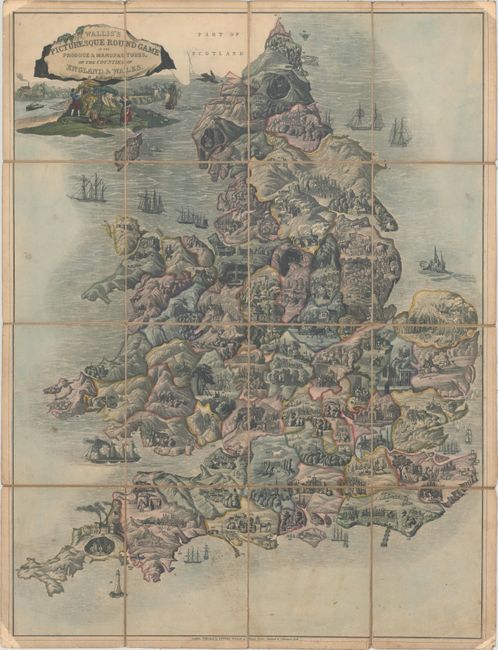
"Wallis's Picturesque Round Game of the Produce & Manufactures, of the Counties of England & Wales", Wallis, Edward
Subject: Cartographic Game, England & Wales
Period: 1830 (circa)
Publication:
Color: Hand Color
Size:
19.1 x 25.2 inches
48.5 x 64 cm
Rare, early map game leads players across England and Wales, stopping at various destinations along the numbered path to learn about the various types of commerce that can be found in various cities and regions. The path begins with #1 near the mouth of the Thames River, and ends at #151 in London. The lovely title cartouche depicts ships and several different types of produce. Aquatint with original hand color, dissected and laid on original linen. The instruction booklet with the rules and descriptions of each numbered location has survived with very few examples, and is not included with this example.
Map games were a popular sideline for cartographic publishers from about 1760 onward in England, with John Bowles publishing the earliest geographical game in 1759. John Wallis Sr. and his son Edward began working together as mapsellers and publishers, and by the 1790s, Wallis' business began to focus on map games, at which point he began to dominate the London market for such items. This business continued up to about 1850 with John's son Edward succeeding his father around 1818.
References:
Condition: B+
Lightly toned and foxed with abrasions in the far corners. Old manuscript ink notation in tital cartouche. Handwritten paper title labels on verso.