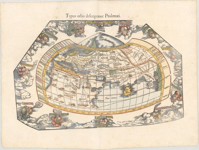
Ptolemaic World Map Surrounded by Wind Heads
"Typus Orbis Descriptione Ptolemaei", Ptolemy/Fries
Subject: Ancient World
Period: 1541 (published)
Publication: Claudii Ptolemaei Alexandrini Geographicae…
Color: Hand Color
Size:
18.1 x 11.7 inches
46 x 29.7 cm
Claudius Ptolemy was a mathematician, astronomer and geographer who worked in Alexandria, then a part of the Roman Empire, in the 2nd century AD. One of the most learned and influential men of his time, his theories dominated both astronomy and geography for nearly 1500 years. His writings were kept alive by Arabic scholars during the Middle Ages and reemerged in Europe during the Renaissance. The birth of printing led to wide dissemination of his great works on astronomy and geography. There were a number of editions of his Geographia beginning in 1477. These early editions contained maps based on his original writings, known as Ptolemaic maps. As geographic knowledge increased with the explorations of Columbus, Magellan, Cabot and others, maps of the New World were added, and maps of the Old World were revised. Ptolemy's Geographia continued to be revised and published by some of the most important cartographers including Martin Waldseemuller, Sebastian Munster, Giacomo Gastaldi, Jodocus Hondius, and Gerard Mercator (whose last edition was published in 1730).
This is one of three world maps included in Fries' Ptolemaic atlas and one of the few early 16th century world maps available to collectors. This striking woodblock world map is a reduced-scale version of Waldseemuller's Ptolemaic map of 1513, which was on the traditional modified conical projection. The area above 65 degrees north is noted as Mare Congelatum (Frozen Sea). The map is surrounded by 12 wind heads representing the classical winds blowing from each direction. This edition was printed by Gaspar Treschel and edited by Michael Villanovus (known as Servetus). Servetus was charged with heresy by John Calvin in 1553, in part due to the text in this atlas. The courts found him guilty and sentenced him to burning at the stake, atop a pyre of his own books, including this atlas.
References: Shirley #47; Mickwitz & Miekkavaara #211-27.
Condition: A
A nice impression on paper with a bunch of grapes watermark, a printer's crease at top, several old manuscript notations, and professional repairs to a few tiny worm holes along the centerfold. Minor marginal soiling.