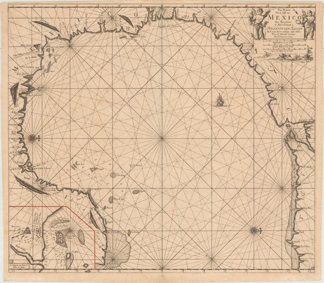
The First Sea Chart of the Western Portion of the Gulf of Mexico
"Pas Kaart van de Golff van Mexico", Keulen, Johannes van
Subject: Gulf of Mexico
Period: 1695 (circa)
Publication:
Color: Hand Color
Size:
23.1 x 20.4 inches
58.7 x 51.8 cm
Two compass roses orient this stunning chart with north to the right. It covers the western portion of the Gulf of Mexico, stretching from the panhandle of Florida around to the Yucatan peninsula. Van Keulen's chart was mostly derived from an exceedingly rare chart by Hessel Gerritsz, c. 1631. Of note, the panhandle of Florida lacks any familiar form and the Baja de Spirito Sancto represents the mouth of the Mississippi River. An inset at lower left shows the seaport of Vera Cruz and the island Fort of San Juan d'Ulloa. The chart was engraved by the eminent geographer and mathematician Claes Janszon Vooght. It originally appeared in Johannes van Keulen's fourth volume of the Zee-Fakkel in 1684. This is the third of four states with shoals added off the coasts of Florida and the Yucatan peninsula.
References: Burden #592; Martin & Martin #11.
Condition: B+
A fine impression with very minor scattered foxing, faint damp stains in top and bottom blank margins, and a very light crease adjacent to centerfold. There is a small amount of hand color in red and yellow.