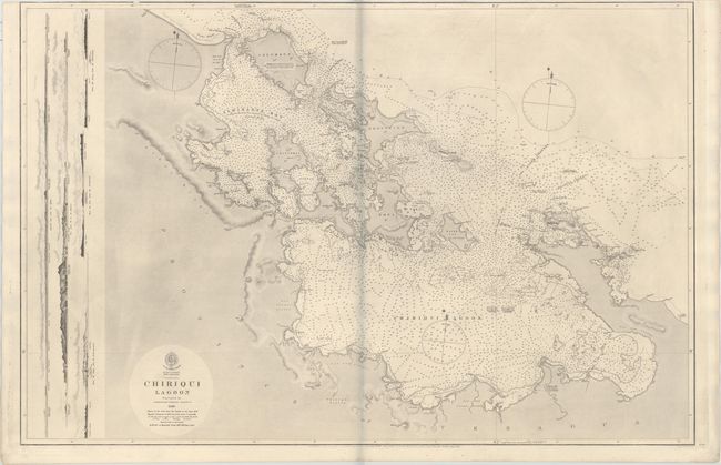
"West Indies New Granada - Chiriqui Lagoon Surveyed by Commander Edward Barnett", British Admiralty
Subject: Bocas del Toro Province, Panama
Period: 1866 (dated)
Publication:
Color: Black & White
Size:
37.7 x 24.8 inches
95.8 x 63 cm
This oversized and highly detailed chart depicts the Bocas del Toro Province along the northwestern coast of Panama, which includes nine main islands, Almirante Bay, and Chiriqui Lagoon. The chart is filled with soundings, the flow of currents, and notations on the type of sea bottom that is found in each area. At left are coastal profile views of various islands and locations along the coast. This map was engraved by J. & C. Walker, published by the Hydrographic Office of the British Admiralty, and sold by J.D. Potter. The initial survey for the map was conducted in 1839 under the command of E. Barnett. The map was first created in 1847, with major corrections made in 1866.
References:
Condition: B+
A very nice example with very minor soiling and offsetting. Trimmed close to the neatline at top, with a few tiny tears that just enter the map border at top. The bluish shadow along the centerfold is caused by our scanner and does not appear on the chart itself.