Catalog Archive
Auction 160, Lot 318

"A Prospective View of the Battle Fought Near Lake George, on the 8th of Sept. 1755, Between 2000 English, with 250 Mohawks...", Pease, R. H.

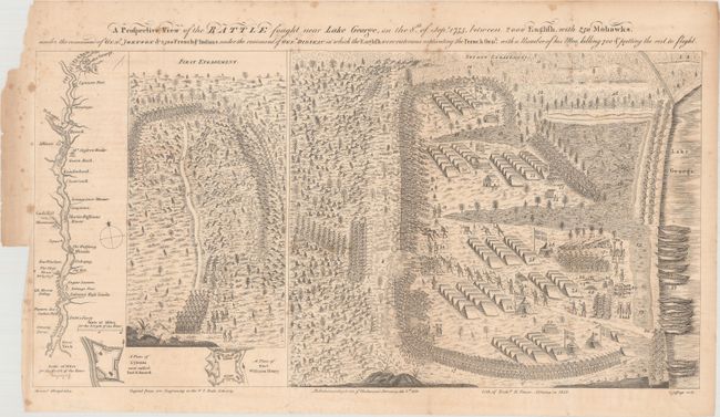
Subject: Lake George, New York

Period: 1852 (dated)

Publication:

Color: Black & White

Size:
19.9 x 10.1 inches
50.5 x 25.7 cm
Download High Resolution Image
(or just click on image to launch the Zoom viewer)

This fascinating battle plan illustrates the Battle of Lake George, the first British victory over the French in the French and Indian War. The title continues: "...under the command of Genl. Johnson & 2500 French & Indians under the command of Genl. Dieskau in which the English were victorious captivating the French Genl. with a number of his men, killing 700 & putting the rest to flight." The map and plans were based on sketches by Samuel Blodget, a provisioner for Sir William Johnson's army. The battle plan is divided into two parts consisting of the first and second engagements of the battle. The sheet also includes bird's-eye plans of Fort Edward and Fort William Henry, as well as a strip map of the Hudson River from New York to Albany, and continuing to Lake George.

Blodget's plans were first published in Boston at the end of 1755, becoming "the first geographic representation of a battle plan published in America" (Schwartz & Ehrenberg). Jeffrey's re-engraved Blodget's plans and published them in London on February 2, 1756. All original examples are extremely rare, and sell for upwards of $35,000. This lithographic reproduction was made by Richard H. Pease in Albany in 1852, copied from an example in the New York State Library.

References: cf. Schwartz & Ehrenberg, p. 163.

Condition: B+

Issued folding with light toning and scattered foxing primarily confined to the blank margins.

Estimate: $300 - $400

Sold for: $150

Closed on 11/16/2016

Archived