"[Lot of 3] Kauai Hawaiian Islands [and] Maui Hawaiian Islands [and] Molokai", U.S. Government
Subject: Kauai, Maui, Molokai
Period: 1897-1903 (dated)
Publication:
Color: Printed Color
This terrific lot collects 3 maps of the Hawaii Territory as surveyed by W.D. Alexander and Walter E. Wall.
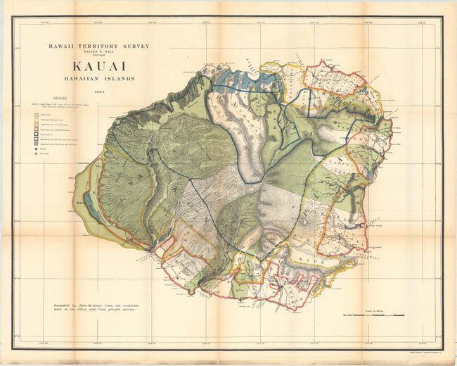
A. Kauai Hawaiian Islands, dated 1903 (30.3 x 23.5"). Brilliantly colored and detailed map of Kauai with information on pineapple and sugar plantations, homesteads, public lands, swampland, and unsurveyed areas. This very attractive example delineates public and private family holdings as well as rice fields, sugar plantations, roads, schools, forts, and the location of a wireless telegraph pole. Hawaii's monarchy was overthrown in 1893, and this map was prepared for the Governor's Annual Report of 1906. The governor at this time was George R. Carter. Compiled by John M. Donn "from all available data in the office and from private surveys." A handsome chart that was printed by the firm of Andrew B. Graham, Lithographers, Washington, D.C.
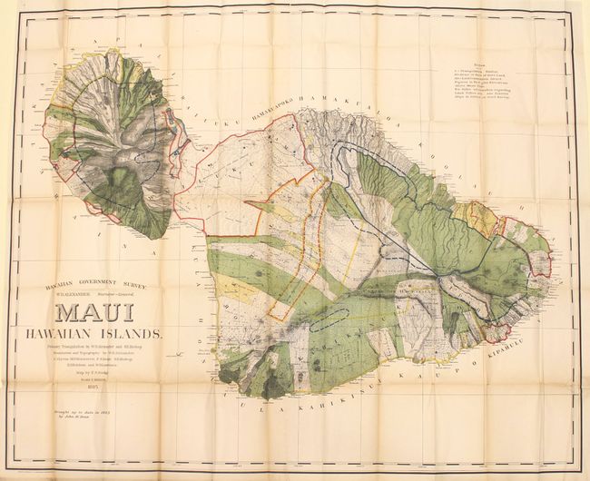
B. Maui Hawaiian Islands, dated 1903 (53.3 x 43.4"). This is a large and handsome map that depicts Maui in great detail shortly after its annexation by the United States. Maui was the main island of the "county group" with a population approaching 40,000. Survey work during the previous decade had resulted in preparation of good maps, but there remained the problem of laying out the lands for settlement under existing land laws. This map delineates those lands for sale, awarded lands, and much more. The map was made under the direction of W.D. Alexander, Surveyor General. It was drawn by F.S. Dodge in 1885, with topography by Alexander, Dodge, C.J. Lyons, M.D. Monsarrat, S.E. Bishop, E.D. Baldwin, and W.R. Lawrence. This edition has been updated to 1903 by John M. Donn.
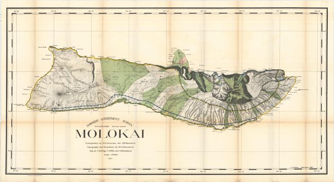
C. Molokai, dated 1897 (48.3 x 25.3"). First edition of this large map produced by W.D. Alexander, the Surveyor-General. It is difficult to imagine a more detailed map of the island - topography, watershed, villages, land grants, coastal detail, lava flows, property owners - it's all here. At the turn of the century numerous valleys supported cattle ranches. On the northern exposure can be seen an area of about six square miles dedicated to a leper colony of about 100 souls. It was established in 1866 and was considered one of the most remarkable institutions of its kind in existence. Triangulation by Alexander and M.D. Monsarrat, who also did the boundaries and topography. The map was drawn by F.S. Dodge, C.J. Willis, and S.M. Kanakanui. A fascinating map of this beautiful island. Condition: Issued folding with light toning along the folds, small splits at some of the fold intersections, and minor offsetting. (B+)
References:
Condition: B+
Issued folding with light toning along the folds, some short splits along the folds, and minor offsetting.