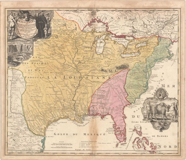
Striking Map of Colonial America with Buffalo Vignette
"Amplissimae Regionis Mississipi seu Provinciae Ludovicianae a R.P. Ludovico Hennepin Francisc Miss in America Septentrionali Anno 1687...", Homann, Johann Baptist
Subject: Colonial Eastern United States & Canada
Period: 1720 (circa)
Publication:
Color: Hand Color
Size:
22.6 x 19.1 inches
57.4 x 48.5 cm
A striking map based on Delisle's landmark map of 1718, but covering a slightly larger area. It focuses on the Mississippi River Valley interior and Great Lakes, also detailing the Gulf Coast region, where the Mission de los Teyas is noted in present-day Texas. The map is splendidly adorned by vignettes of a buffalo and Native Americans in a cartouche filling the Atlantic, and a beaver colony at Niagara Falls under the title cartouche at upper left. Also depicted in the title cartouche is Father Louis Hennepin who explored the Great Lakes region and claimed to have reached the mouth of the Mississippi. The routes of Hennepin, de Soto and other explorers are traced in the map.
References: McCorkle #720.1; Goss (NA) #49; cf. Wheat (TMW) #144; cf. Cumming (SE) #170.
Condition: B
On watermarked paper with light toning along the centerfold and sheet edges, and a repaired edge tear and centerfold separation at bottom that both just pass the border. There are several tiny worm holes and a few worm tracks in the image that are only visible when held to light.