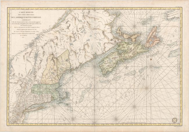
"Carte Reduite des Cotes Orientales de l'Amerique Septentrionale. Contenant Celles des Provinces de New-York et de la Nouvelle Angleterre, Celles de l'Acadie ou Nouvelle Ecosse...", Sartine
Subject: Colonial Northeastern United States & Canada
Period: 1780 (dated)
Publication: Neptune Americo-Septentrional
Color: Hand Color
Size:
33.8 x 22.9 inches
85.9 x 58.2 cm
This fine chart was prepared under the direction of Antoine Sartine, Minister of Marine in Paris for use by the French Navy during the American Revolutionary War. It covers the region from Chaleur Bay to New Jersey and includes Prince Edward Island and Cape Breton Island. It provides excellent detail of the harbors, bays, inlets, shoals and fishing banks, currents and navigational hazards. In addition to the hydrographical detail it also includes interior information in New England on the towns and forts. The reference in the title to vaisseux du roi has been changed to vaisseux Francaise indicating publication after the French Revolution. The engraved Depot de la Marine stamp appears at bottom right. This is the second state with No. 1 (Hyd. No. 61) in top right margin and Prix Trois Livres in bottom right margin.
References: McCorkle #780.3; Kershaw #754; Sellers & Van Ee #216.
Condition: B+
Nice impression and color on heavy, watermarked paper with very light soiling, a printer's crease in bottom right corner, and a few minor extraneous creases along centerfold. A very nice example of this large map. There is a faint shadow that appears along the centerfold that is caused by our scanner and does not appear on the map.