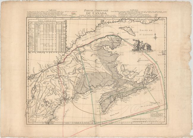
Map Depicting French and British Claims in the Canadian Maritimes
"Partie Orientale du Canada Traduitte de l'Anglois de la Carte de Jefferys Publiee a Londres...", Le Rouge, George Louis
Subject: Colonial Northeastern United States & Canada
Period: 1755 (dated)
Publication: Atlas General Contenant le Detail des Quatre Parties du Monde
Color: Hand Color
Size:
24.1 x 18.6 inches
61.2 x 47.2 cm
This is the first state of Le Rouge's rare map of northern New England and southeastern Canada depicting the various French and British claims to territory in the region. The map extends from Boston in the south to the mouth of St. Lawrence River in the north, and includes the Ile d'Anticosti, Nova Scotia, and the tip of Newfoundland (Isle de Terre Neuve). The dotted and colored lines represent the various regions ceded based on the Treaties of Utrecht and Breda, as explained at top left. A table at left compares the coordinates of various locations from maps by different cartographers. In the US, only the Province of Maine is marked, with a number of coastal towns named. Numerous other forts, towns, rivers, lakes and Indian lands are named. The map is adorned with a compass rose and a vignette of Neptune with his chariot. The map is based on Jefferys' map also from 1755, "A New Map of Nova Scotia, and Cape Britain, with the Adjacent Parts of New England and Canada."
References: Kershaw #741; Phillips (Maps), p. 191; Sellers & Van Ee #31.
Condition: B+
Original outline color on watermarked paper with wide margins and light toning and creasing along centerfold. There is a small abrasion along centerfold near the St. Lawrence River, and several chips and repaired tears in blank margins, far from map image, with marginal soiling.