Catalog Archive
Auction 160, Lot 127

"Le Canada ou Partie de la Nouvelle France dans l'Amerique Septentrionale, Contenant la Terre de Labrador, la Nouvelle France, les Isles de Terre Neuve, de Nostre Dame, etc.", Jaillot, Alexis-Hubert

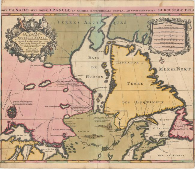
Subject: Eastern Canada

Period: 1696 (dated)

Publication:

Color: Hand Color

Size:
23.6 x 18.1 inches
59.9 x 46 cm
Download High Resolution Image
(or just click on image to launch the Zoom viewer)

This bold map includes some cartographically important depictions of interior rivers and lakes. It also locates French and English fur trading posts. The island-filled lake north of Lake Superior is based on Indian reports and actually represents the lake region of Manitoba. The correct shape for Hudson Bay is based on English discoveries and Port Nelson is well located. Two unnamed lakes near the source of the Nelson River provide an early depiction of Lake Winnipeg, although they are located too far to the east. A large, spurious Lac des Poux is shown west of Hudson Bay. The rivers south of Hudson Bay are also well delineated. The Latin title, "Nova Canadae sive Novae Franciae in America Septentrionali Tabula..." appears in the top margin. This is the second state with the date updated from 1695 to 1696.

References: Kershaw #174.

Condition: B

Sharp impression with bold original color, light soiling, and one tiny abrasion in the map along the centerfold. The side margins were trimmed by the binder to fit into an atlas, with loss of a portion of the border and the first and last letter in the title above the map.

Estimate: $800 - $950

Sold for: $400

Closed on 11/16/2016

Archived