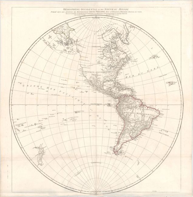
"Hemisphere Occidental ou du Nouveau Monde Publie sous les Auspices de Monseigneur Louis Philippe...", Anville, Jean Baptiste Bourguignon d'
Subject: Western Hemisphere - America
Period: 1761 (dated)
Publication:
Color: Hand Color
Size:
24.1 x 25.7 inches
61.2 x 65.3 cm
Attractive hemispheric map by Jean Baptiste Bourguinon d'Anville, geographer to King Louis XIV, was among the most respected cartographers of his day. He was an early advocate of leaving blank spaces on maps where knowledge was insufficient. The northwest coast of North America is largely blank except for references to the supposed discoveries of Admiral de Fonte. A dotted line depicts the R. courant a l'Ouest connecting Lake Winnipeg with the Pacific. The Russian discoveries are shown with a rough outline of Alaska. Although the map is dated 1761, it was clearly published after 1774, as evidenced by the completed coastlines of the two islands of New Zealand and the notation near Antarctica that Captain Cook had reached 71 degrees of latitude, which occurred on January 31, 1774.
References:
Condition: B+
Issued folding with original outline color on watermarked paper and an extraneous horizontal fold. There is minor soiling, faint damp stains in top corners, and the folds have been professionally reinforced on verso.