Catalog Archive
Auction 159, Lot 644

Ortelius' Influential Map of Japan

"Iaponiae Insulae Descriptio. Ludoico Teisera Auctore", Ortelius, Abraham

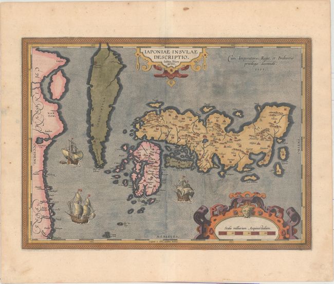
Subject: Japan & Korea

Period: 1595 (dated)

Publication: Theatrum Orbis Terrarum

Color: Hand Color

Size:
18.8 x 13.9 inches
47.8 x 35.3 cm
Download High Resolution Image
(or just click on image to launch the Zoom viewer)

This landmark map was the first map of Japan published in a European atlas. Ortelius received the map from Ludovico Teixeira, a Portuguese Jesuit cartographer and mathematician. While Teixeira had not personally traveled to Japan, he obviously had access to Japanese sources as the map presents the first reasonably accurate and recognizable depiction of the island nation with numerous Japanese place names. Korea appears as an island tapering to a point labeled Punta dos ladrones. The map is elegantly embellished with three large galleons, two elaborate cartouches, and a boldly engraved border. This influential map was to become the basis for many other cartographers' maps of Japan for more than fifty years. Latin text on verso with page number 110, published in 1603.

References: Van den Broecke #165; Walter OAG #5, plt. 19.

Condition: A

A crisp impression on watermarked paper with a light vertical crease adjacent to the centerfold and some minor surface soil.

Estimate: $3,250 - $4,000

Sold for: $1,700

Closed on 9/14/2016

Archived